IMAGES TAKEN NEAR TO
Whateleys Drive, KENILWORTH, CV8 2GY
Introduction
This page details the photographs taken nearby to Whateleys Drive, CV8 2GY by members of the Geograph project.
The Geograph project started in 2005 with the aim of publishing, organising and preserving representative images for every square kilometre of Great Britain, Ireland and the Isle of Man.

There are currently over 7.5m images from over14,400 individuals and you can help contribute to the project by visiting https://www.geograph.org.uk
Image Map (Loading...)


Getting Data...Please wait
Leaflet Map data © OpenStreetMap
Images are licensed for reuse under creativecommons.org/licenses/by-sa/2.0
Notes
- Clicking on the map will re-center to the selected point.
- The higher the marker number, the further away the image location is from the centre of the postcode.
Image Listing (225 Images Found)
Images are licensed for reuse under creativecommons.org/licenses/by-sa/2.0
Image
Details
Distance
1
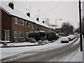
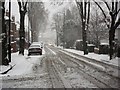
Whateleys Drive in the snow
Whateleys Drive was originally the access drive from Priory Road to Whateleys nurseries which stood on this spot until the 1960's. The junction with Offa Drive is on the left.
The buildings on the left are maisonettes (individual flats on ground and first floors with their own entrance doors at ground level). They are of a design which is repeated elsewhere in the town such as at Denton Close by the castle.
Image: © John Brightley
Taken: 18 Dec 2010
0.01 miles
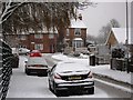
2
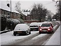
Car moving slowly along Whateleys Drive in the snow
Image: © John Brightley
Taken: 18 Dec 2010
0.02 miles
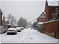
4
Whateleys Drive in the snow
The houses in the background are in Spring Lane.
Image: © John Brightley
Taken: 18 Dec 2010
0.07 miles
6
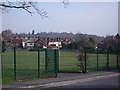
Spring Lane and Henry St seen from Whateleys Drive
A view across St Nicholas School playing fields to the rear of houses in Spring Lane, with houses in Henry St behind and the trees of Kenilworth Common in the distance.
Image: © John Brightley
Taken: 10 Apr 2010
0.08 miles
7
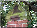
Pier cap detail, Priory Road
Stone pier cap of garden wall of Edwardian property which stands at the corner of Priory Road and Whateleys Drive.
Image: © John Brightley
Taken: 10 Apr 2010
0.08 miles
8
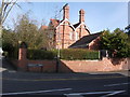
Priory Road/ Whateleys Drive junction, Kenilworth
When this Edwardian house was built, Whateleys Drive was simply the entrance to the nurseries run by the Whateley family. It was only turned into a public road in the 1950's or 60's when houses and flats were built on the nursery site.
Note the arch feature in the garden wall - possibly built as a 'relieving arch' to take the load off tree roots in the vicinity?
Image: © John Brightley
Taken: 10 Apr 2010
0.08 miles
9
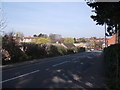
Spring Lane looking towards Whateleys Drive
Taken from near the railway bridge. The bungalows of Offa Drive are behind the hedgerow. Allotments off picture to the right. St Nicholas school in the background.
Image: © John Brightley
Taken: 10 Apr 2010
0.08 miles
10
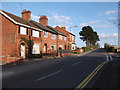
Spring Lane, Kenilworth
The junction with Whateleys Drive is on the right. The road is raised up above the surrounding ground on an embankment presumably built when the railway was constructed. It crosses the railway and becomes Whitemoor Road on the brow of the hill in the distance.
Image: © John Brightley
Taken: 14 Apr 2010
0.08 miles