IMAGES TAKEN NEAR TO
Reeve Drive, KENILWORTH, CV8 2GA
Introduction
This page details the photographs taken nearby to Reeve Drive, CV8 2GA by members of the Geograph project.
The Geograph project started in 2005 with the aim of publishing, organising and preserving representative images for every square kilometre of Great Britain, Ireland and the Isle of Man.

There are currently over 7.5m images from over14,400 individuals and you can help contribute to the project by visiting https://www.geograph.org.uk
Image Map
Images are licensed for reuse under creativecommons.org/licenses/by-sa/2.0
Notes
- Clicking on the map will re-center to the selected point.
- The higher the marker number, the further away the image location is from the centre of the postcode.
Image Listing (216 Images Found)
Images are licensed for reuse under creativecommons.org/licenses/by-sa/2.0
Image
Details
Distance
1
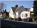
Kenilworth Methodist Church, Priory Road, Kenilworth
Image: © John Brightley
Taken: 17 Apr 2010
0.05 miles
2
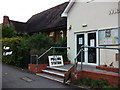
Polling Station B, Methodist Church, Priory Road, Kenilworth
Polling station for the General Election.
Image: © John Brightley
Taken: 6 May 2010
0.06 miles
3
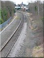
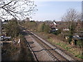
Railway track , Kenilworth Warwicks.
The single track runs N-S through Kenilworth from Coventry to Leamington Spa. It links the Paddington-Birmingham line with the Euston-Birmingham line. Kenilworth station was just beyond the footbridge in the distance.
Image: © Nigel Mykura
Taken: 23 Feb 2008
0.07 miles
5
Railway line at Spring Lane, Kenilworth
Looking south towards the site of the station.
Image: © John Brightley
Taken: 10 Apr 2010
0.07 miles
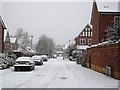
6
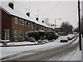
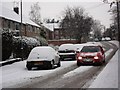
Whateleys Drive in the snow
Whateleys Drive was originally the access drive from Priory Road to Whateleys nurseries which stood on this spot until the 1960's. The junction with Offa Drive is on the left.
The buildings on the left are maisonettes (individual flats on ground and first floors with their own entrance doors at ground level). They are of a design which is repeated elsewhere in the town such as at Denton Close by the castle.
Image: © John Brightley
Taken: 18 Dec 2010
0.08 miles
8
Cherry Way, Kenilworth
The view of the end of Cherry Way from Spring Lane railway bridge. The Holiday Inn in the town centre can just be seen on the skyline.
Image: © John Brightley
Taken: 10 Apr 2010
0.08 miles
9
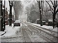
Car moving slowly along Whateleys Drive in the snow
Image: © John Brightley
Taken: 18 Dec 2010
0.08 miles
10
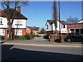
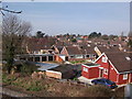
Alexandra Court, Priory Road, Kenilworth
In the centre of the photo can be seen the entrance to the housing of Alexandra Court. In the far background can be seen the rear of houses in Reeve Drive.
To the right of the photo can be seen the Bailey Buildbase premises and, just to the left of it, the narrow entrance to the public footpath which leads over a footbridge to Farmer Ward Road. This footpath is the oldest feature of the area - it existed before Priory Road was built and leads from the centre of Kenilworth out in an easterly direction through housing estates and eventually to Stoneleigh Abbey.
Image: © John Brightley
Taken: 17 Apr 2010
0.09 miles