IMAGES TAKEN NEAR TO
The Gardens, KENILWORTH, CV8 2DX
Introduction
This page details the photographs taken nearby to The Gardens, CV8 2DX by members of the Geograph project.
The Geograph project started in 2005 with the aim of publishing, organising and preserving representative images for every square kilometre of Great Britain, Ireland and the Isle of Man.

There are currently over 7.5m images from over14,400 individuals and you can help contribute to the project by visiting https://www.geograph.org.uk
Image Map (Loading...)


Getting Data...Please wait
Leaflet Map data © OpenStreetMap
Images are licensed for reuse under creativecommons.org/licenses/by-sa/2.0
Notes
- Clicking on the map will re-center to the selected point.
- The higher the marker number, the further away the image location is from the centre of the postcode.
Image Listing (64 Images Found)
Images are licensed for reuse under creativecommons.org/licenses/by-sa/2.0
Image
Details
Distance
1
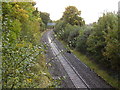
Looking north
A single track railway line running through Kenilworth. Viewed from the Clarkes Lane footbridge.
Image: © Anthony Vosper
Taken: 13 Oct 2012
0.11 miles
4
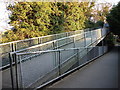
Ramp leading to railway footbridge, Clarendon Road, Kenilworth
At the Clarendon Road end of the bridge that leads to Farmer Ward Road is this long ramp.
Image: © John Brightley
Taken: 14 Apr 2010
0.13 miles
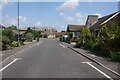
5
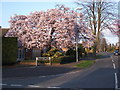
Spring blossom, Blackthorn Road, Kenilworth
At the junction with Farmer Ward Road. There were a number of trees in blossom in the surrounding area, but this was by far the best.
Image: © John Brightley
Taken: 14 Apr 2010
0.13 miles
6
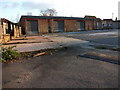
Builders merchants yard, Clarendon Road, Kenilworth
Seen from the Clarendon Road entrance. Also see Image]
Image: © John Brightley
Taken: 14 Apr 2010
0.15 miles
7
Clarkes Avenue footpath
The path crosses over a single track railway line.
Image: © Anthony Vosper
Taken: 13 Oct 2012
0.15 miles
8

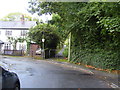
The wall remains
Behind this wall used to lie a Victorian mansion and mini-estate called The Hermitage. The main house is long-demolished and the land built over. This wall and what appears to be a blocked up entrance are all that remain.
Image: © Colin Craig
Taken: 1 Feb 2009
0.15 miles
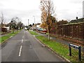
9
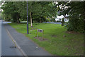
Birches Lane Kenilworth
Taken to show the street sign rather than anything else. This is another very leafy suburb of Kenilworth.
Image: © Malcolm Neal
Taken: 26 May 2017
0.15 miles
10
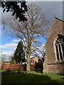
St John, Kenilworth: tree in the churchyard
Image: © Basher Eyre
Taken: 11 Feb 2019
0.16 miles