IMAGES TAKEN NEAR TO
Leamington Road, KENILWORTH, CV8 2AA
Introduction
This page details the photographs taken nearby to Leamington Road, CV8 2AA by members of the Geograph project.
The Geograph project started in 2005 with the aim of publishing, organising and preserving representative images for every square kilometre of Great Britain, Ireland and the Isle of Man.

There are currently over 7.5m images from over14,400 individuals and you can help contribute to the project by visiting https://www.geograph.org.uk
Image Map (37 Images)


Getting Data...Please wait
Leaflet Map data © OpenStreetMap
Images are licensed for reuse under creativecommons.org/licenses/by-sa/2.0
Notes
- Clicking on the map will re-center to the selected point.
- The higher the marker number, the further away the image location is from the centre of the postcode.
Image Listing (37 Images Found)
Images are licensed for reuse under creativecommons.org/licenses/by-sa/2.0
Image
Details
Distance
1
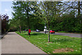
Leamington Road, Kenilworth
A service road divides the houses from the main carriageway of the A452 on the outskirts of Kenilworth. A view in the opposite direction, featuring the postbox: Image
Image: © Stephen McKay
Taken: 8 May 2016
0.03 miles
2
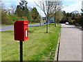
Postbox along Leamington Road, Kenilworth
Image: © Mat Fascione
Taken: 18 Apr 2015
0.06 miles
3
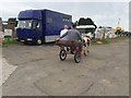
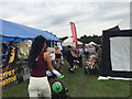
Driving at Kenilworth Horse Fair
A piebald pony draws a two-wheeled, two-seater gig or buggy.
Image: © Robin Stott
Taken: 24 Sep 2016
0.08 miles
4

Leamington Road, Kenilworth
The A452 approaches its junction with the A46 on the outskirts of Kenilworth.
Image: © Stephen McKay
Taken: 8 May 2016
0.09 miles
5
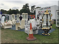
Furniture display, Kenilworth Horse Fair
Is it really for travellers' caravans?
Image: © Robin Stott
Taken: 24 Sep 2016
0.10 miles
6
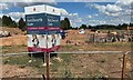
Kenilworth extends
This looks like the land that was host to the Kenilworth Horse Fair Image It is being developed for housing, branded 'Kenilworth Gate' by Charles Church.
Photo number 7566687.
Image: © Robin Stott
Taken: 31 Aug 2022
0.10 miles
7
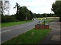
Leamington Road, Kenilworth -view towards Thickthorn roundabout
This is the main entrance to Kenilworth from the A46. The posts adjacent to the brick flower bed in the foreground usually hold a town name sign but this has been stolen recently, as has a direction sign on the roundabout. So at the moment visitors just have to guess that they have arrived in the town !
The road on the right is a short service road serving the last few houses at this end of Kenilworth. The land behind the trees and hedge on the left is likely to be the next parcel of land on the town boundaries to be developed when expansion is needed in the future.
Image: © John Brightley
Taken: 30 Aug 2010
0.12 miles
8
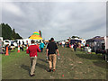
Main thoroughfare, Kenilworth Horse Fair 2016
Image: © Robin Stott
Taken: 24 Sep 2016
0.13 miles
9
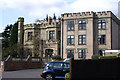
Changed times
This is a former mansion called Thickthorn in Kenilworth which has been converted into a care home. The block to the right is a modern extension as part of its new role. At least this mansion has survived. Kenilworth had a mini-boom in Victorian times with several large mansions built in their own grounds on the then-outskirts. Most have been demolished and built over. The grounds of this mansion are also now mostly covered in housing. This mansion may have been slightly later than some others as the surviving stable block adjacent (converted to housing) has the date 1907 on it.
Image: © Colin Craig
Taken: 22 Mar 2009
0.15 miles
10
Window-shopping, Kenilworth Horse Fair
Image: © Robin Stott
Taken: 24 Sep 2016
0.15 miles