IMAGES TAKEN NEAR TO
Moorlands Avenue, KENILWORTH, CV8 1RT
Introduction
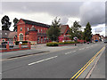
This page details the photographs taken nearby to Moorlands Avenue, CV8 1RT by members of the Geograph project.
The Geograph project started in 2005 with the aim of publishing, organising and preserving representative images for every square kilometre of Great Britain, Ireland and the Isle of Man.

There are currently over 7.5m images from over14,400 individuals and you can help contribute to the project by visiting https://www.geograph.org.uk
Image Map (Loading...)


Getting Data...Please wait
Leaflet Map data © OpenStreetMap
Images are licensed for reuse under creativecommons.org/licenses/by-sa/2.0
Notes
- Clicking on the map will re-center to the selected point.
- The higher the marker number, the further away the image location is from the centre of the postcode.
Image Listing (91 Images Found)
Images are licensed for reuse under creativecommons.org/licenses/by-sa/2.0
Image
Details
Distance
1
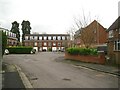
The south end of Regency Drive, off Queen's Road, Kenilworth
This is a (backland?) development that extends Regency Drive: maisonettes over garages or 3-storey town houses with integral garages. There is a row of lock-up garages on each side of the street, nearer the camera.
Image: © Robin Stott
Taken: 4 Apr 2015
0.04 miles
2
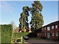
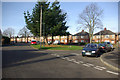
Trees tell the tale
The coming of the railway to Kenilworth in Victorian times saw an influx of industrialists from Birmingham and elsewhere, who created large mansions and mini country estates on the edges of the town. Few are left as the value of the land for building plots in the 20th century outweighed any preservation considerations and often all that's left are the specimen trees planted by the original owners, as in this pic. These trees are on the approximate site of Moorlands, a mansion long since demolished for housing.
Image: © Colin Craig
Taken: 30 Jan 2009
0.06 miles
3
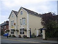
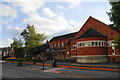
The Peacock
An hotel belonging to the Best Western chain on Warwick Road in Kenilworth
Image: © David Stowell
Taken: 23 Oct 2005
0.07 miles
4
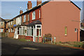
Roseland Road, Kenilworth
Roseland Road is a continuation of St Johns Street from the main Warwick Road. These houses are set at right angles to the road itself.
Image: © Stephen McKay
Taken: 27 Jan 2008
0.08 miles
5
Roseland Road, Kenilworth
Looking along Roseland road from its junction with Guy Road.
Image: © Stephen McKay
Taken: 27 Jan 2008
0.09 miles
6
St Francis of Assisi Church, Kenilworth
The main Roman Catholic church in the town.
Image: © Bill Boaden
Taken: 21 Sep 2013
0.09 miles
7
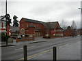
Kenilworth, Catholic church
St. Francis of Assisi RC Church, on Warwick Road. http://catholic-kenilworth.org/
Image: © Mike Faherty
Taken: 13 Mar 2011
0.09 miles
8
St Francis of Assisi Catholic Church, Kenilworth
Image: © Bill Boaden
Taken: 21 Sep 2013
0.09 miles
9

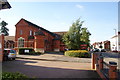
Warwick Road Kenilworth
This part of Warwick Road is closer to the centre of Kenilworth. It becomes more of a shopping than a housing area the closer you get to the centre.
Image: © Malcolm Neal
Taken: 26 May 2017
0.09 miles
10
St Francis of Assissi Roman Catholic Church, Kenilworth
Image: © David Dixon
Taken: 7 Aug 2011
0.10 miles