IMAGES TAKEN NEAR TO
Red Lane, KENILWORTH, CV8 1NY
Introduction
This page details the photographs taken nearby to Red Lane, CV8 1NY by members of the Geograph project.
The Geograph project started in 2005 with the aim of publishing, organising and preserving representative images for every square kilometre of Great Britain, Ireland and the Isle of Man.

There are currently over 7.5m images from over14,400 individuals and you can help contribute to the project by visiting https://www.geograph.org.uk
Image Map (Loading...)


Getting Data...Please wait
Leaflet Map data © OpenStreetMap
Images are licensed for reuse under creativecommons.org/licenses/by-sa/2.0
Notes
- Clicking on the map will re-center to the selected point.
- The higher the marker number, the further away the image location is from the centre of the postcode.
Image Listing (7 Images Found)
Images are licensed for reuse under creativecommons.org/licenses/by-sa/2.0
Image
Details
Distance
2
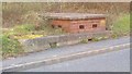
A possible WWII pill box in Red Lane, Kenilworth
Aficionados of WWII pill boxes may like to comment on this structure.
Image: © John Evans
Taken: 28 Mar 2012
0.09 miles
3
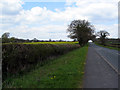
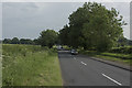
Near Drake's Hollow
Looking north along Red Lane. The location to the left is named as Drake's Hollow.
Image: © E Gammie
Taken: 16 Apr 2012
0.10 miles
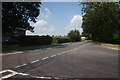
4
Red Lane, north of Kenilworth
Old maps show this still as farmland in 1926; this classic ribbon development is first shown on a map of 1938. It is one of the many suburban implants into the southern Arden countryside; the wide hedge with some holly is characteristic.
Image: © Robin Stott
Taken: 25 Oct 2017
0.20 miles
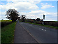
5
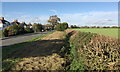
Looking towards Drake's Hollow
The road just visible at the end of this road is Birmingham Road. Both sides of the road have lush farmland that are used for arable farming.
Image: © Malcolm Neal
Taken: 31 May 2018
0.20 miles
6
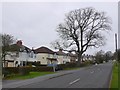
Red Lane Kenilworth
Just outside the town on the northwest side. It is an unusual development in that the houses are only on one side of the road and there is very little other residential development. The Red may have referred to the clay or the local sandstone which is red.
Image: © Nigel Mykura
Taken: 6 Mar 2011
0.23 miles