IMAGES TAKEN NEAR TO
Fishponds Road, KENILWORTH, CV8 1EX
Introduction
This page details the photographs taken nearby to Fishponds Road, CV8 1EX by members of the Geograph project.
The Geograph project started in 2005 with the aim of publishing, organising and preserving representative images for every square kilometre of Great Britain, Ireland and the Isle of Man.

There are currently over 7.5m images from over14,400 individuals and you can help contribute to the project by visiting https://www.geograph.org.uk
Image Map (Loading...)


Getting Data...Please wait
Leaflet Map data © OpenStreetMap
Images are licensed for reuse under creativecommons.org/licenses/by-sa/2.0
Notes
- Clicking on the map will re-center to the selected point.
- The higher the marker number, the further away the image location is from the centre of the postcode.
Image Listing (34 Images Found)
Images are licensed for reuse under creativecommons.org/licenses/by-sa/2.0
Image
Details
Distance
1
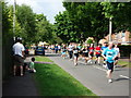
Two Castles Run in Fishponds Road 2010
On the route of the annual run between Kenilworth and Warwick castles.
Image: © John Brightley
Taken: 6 Jun 2010
0.01 miles
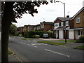
2
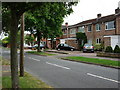
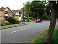
Housing in Fishponds Road
The southern side of the road seen from the junction with John O'Gaunt Road.
Image: © John Brightley
Taken: 26 May 2010
0.02 miles
3
The junction of Fishponds Road and Caesar Road, Kenilworth
Seen on the occasion of the Two Castles Run 2010.
Image: © John Brightley
Taken: 6 Jun 2010
0.04 miles
4
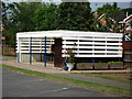
Cycle store, Clinton Primary School
I get the impression that this shelter was probably built at the same time as the school as the horizonally boarded design seems to have a 1960's feel.
Image: © John Brightley
Taken: 6 Jun 2010
0.04 miles
5
The northern end of John O'Gaunt Road
Where it joins Fishponds Road (to the right).
Image: © John Brightley
Taken: 26 May 2010
0.05 miles
6
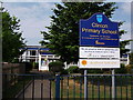
Entrance to Clinton Primary School, Kenilworth
Image: © John Brightley
Taken: 6 Jun 2010
0.06 miles
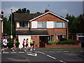
7
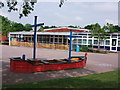
Clinton Primary School. Caesar Road, Kenilworth
A 1960's building built at the same time as the adjoining housing estate, with galleon-shaped play equipment in the playground.
Image: © John Brightley
Taken: 6 Jun 2010
0.07 miles
8
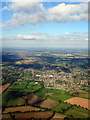
Kenilworth from the west
Viewed from a flight from Aberdeen landing at Birmingham.
Image: © John Lucas
Taken: 22 Sep 2016
0.08 miles
9
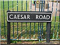
Street name sign, Caesar Road, Kenilworth
An interesting sign outside Clinton Primary School as under closer inspection one can see that the name was originally cast and erected as 'Caesar's Road', but the ''s' has been painted out.
Image: © John Brightley
Taken: 6 Jun 2010
0.09 miles
10
Houses in John O'Gaunt Road
These houses on the west side of the road back on to the fields of Oaks Farm.
Image: © John Brightley
Taken: 26 May 2010
0.10 miles