IMAGES TAKEN NEAR TO
Featherbed Lane, COVENTRY, CV7 9LY
Introduction
This page details the photographs taken nearby to Featherbed Lane, CV7 9LY by members of the Geograph project.
The Geograph project started in 2005 with the aim of publishing, organising and preserving representative images for every square kilometre of Great Britain, Ireland and the Isle of Man.

There are currently over 7.5m images from over14,400 individuals and you can help contribute to the project by visiting https://www.geograph.org.uk
Image Map
Images are licensed for reuse under creativecommons.org/licenses/by-sa/2.0
Notes
- Clicking on the map will re-center to the selected point.
- The higher the marker number, the further away the image location is from the centre of the postcode.
Image Listing (5 Images Found)
Images are licensed for reuse under creativecommons.org/licenses/by-sa/2.0
Image
Details
Distance
1
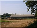
Withybrook
Farm Buildings at Withybrook Grange.
Image: © Ian Rob
Taken: 26 Jul 2006
0.06 miles
3
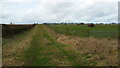
Path through farmland
This path leads through fields east of Withybrook.
Image: © Peter Mackenzie
Taken: 1 Mar 2017
0.14 miles
4
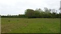
Grassland near Withybrook Grange
Rough grazing and hedges mark the landscape in this isolated spot.
Image: © Peter Mackenzie
Taken: 29 Apr 2017
0.22 miles
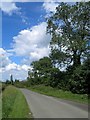
5
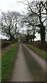
Minor road to Lodge Farm
This quiet rural cul-de-sac leads from Withybrook to Lodge Farm.
Image: © Peter Mackenzie
Taken: 1 Mar 2017
0.24 miles