IMAGES TAKEN NEAR TO
St. Giles Road, COVENTRY, CV7 9HB
Introduction
This page details the photographs taken nearby to St. Giles Road, CV7 9HB by members of the Geograph project.
The Geograph project started in 2005 with the aim of publishing, organising and preserving representative images for every square kilometre of Great Britain, Ireland and the Isle of Man.

There are currently over 7.5m images from over14,400 individuals and you can help contribute to the project by visiting https://www.geograph.org.uk
Image Map
Images are licensed for reuse under creativecommons.org/licenses/by-sa/2.0
Notes
- Clicking on the map will re-center to the selected point.
- The higher the marker number, the further away the image location is from the centre of the postcode.
Image Listing (28 Images Found)
Images are licensed for reuse under creativecommons.org/licenses/by-sa/2.0
Image
Details
Distance
1
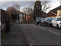
Deans Way
A small estate of houses between St Giles Lane and Vicarage Lane. This is taken from Dean Way's junction with St Giles Lane.
Image: © Niki Walton
Taken: 29 Dec 2018
0.10 miles
2
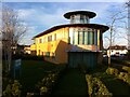
Former Pears Centre, Ash Green
This is the administration building of the former Pears Centre, a residential school complex built and run by the Royal National Institute of Blind People (RNIB) between 2011 and 2018 as the RNIB Pears Centre for Specialist Learning. For more on this school see the Wikipedia article here https://en.wikipedia.org/wiki/RNIB_Pears_Centre_for_Specialist_Learning and this Third Sector article on its closure https://www.thirdsector.co.uk/rnib-close-inadequate-childrens-home-loss-180-jobs/management/article/1491802 . The site was bought by Warwickshire County Council in 2019 and is being redeveloped as a Special Educational Needs and Disabilities (SEND) school; see this Warwickshire County Council document https://democracy.warwickshire.gov.uk/documents/s11173/NBB20CC005%20-%20Proposed%20segregation%20fencing%20vehicular%20access%20gates%20for%20Hydrotherapy%20Pool%20area%20at%20th.pdf .
Image: © A J Paxton
Taken: 22 Mar 2020
0.11 miles
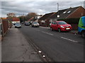
3
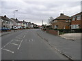
Suburbia and Football
This suburban street in Neal's Green has as a backdrop the new Ricoh Stadium.
Image: © Michael Patterson
Taken: 21 Mar 2006
0.13 miles
4
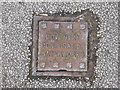
Coventry Corporation Waterworks
Detail in the pavement at the corner of Wheelwright Lane and Woodford Close.
Image: © Niki Walton
Taken: 29 Dec 2018
0.14 miles
5
Calcutt's Livery Services
My cousin boarded her horse here in the 1980s, I'm assuming the setup is the same now - a large stables block and two substantial paddocks beyond.
Image: © Niki Walton
Taken: 29 Dec 2018
0.14 miles
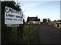
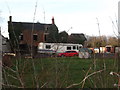
6
Exhall House, Blackberry Lane CV7
A sign advertises Calcutt's Livery Stables.
Image: © Robin Stott
Taken: 11 Oct 2010
0.15 miles

9
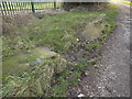
Remnants on Blackberry Lane
Several rectangular blocks and one irregular block on the side of the trackway on Blackberry Lane. There's no other indication of what these were previously part of.
Image: © Niki Walton
Taken: 29 Dec 2018
0.16 miles
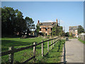
10
Exhall House
Not sure how long it's been derelict, but it appears to be sinking into the dust already.
Image: © Niki Walton
Taken: 29 Dec 2018
0.16 miles