IMAGES TAKEN NEAR TO
Church Lane, COVENTRY, CV7 9GY
Introduction
This page details the photographs taken nearby to Church Lane, CV7 9GY by members of the Geograph project.
The Geograph project started in 2005 with the aim of publishing, organising and preserving representative images for every square kilometre of Great Britain, Ireland and the Isle of Man.

There are currently over 7.5m images from over14,400 individuals and you can help contribute to the project by visiting https://www.geograph.org.uk
Image Map
Images are licensed for reuse under creativecommons.org/licenses/by-sa/2.0
Notes
- Clicking on the map will re-center to the selected point.
- The higher the marker number, the further away the image location is from the centre of the postcode.
Image Listing (47 Images Found)
Images are licensed for reuse under creativecommons.org/licenses/by-sa/2.0
Image
Details
Distance
1
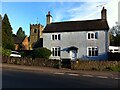
Former schoolhouse, Exhall, with parish church behind
Former schoolhouse of Exhall parish, dated 1813 on an inscription on the front, now a private house on Church Lane, Ash Green. Exhall Church of England parish church can be seen behind and to the left. This is the Exhall in North Warwickshire, now a suburb of Bedworth, not the village of the same name in south Warwickshire, near to Stratford-upon-Avon.
Image: © A J Paxton
Taken: 30 May 2021
0.00 miles
2
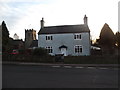
Former schoolhouse, Church Lane
Now a private house - a plaque above the door gives details of the building's original purpose.
Image: © Niki Walton
Taken: 29 Dec 2018
0.00 miles
3
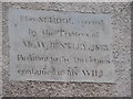
Plaque on wall of former schoolhouse
The former schoolhouse is located on Church Lane, close to St Giles Church, and is now a private house. This plaque is located above the door and reads "This SCHOOL erected by the Trustees of Mr A. W. BENTLEY 1813. Pursuant to the Directions contained in his WILL."
Image: © Niki Walton
Taken: 29 Dec 2018
0.00 miles
4
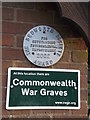
Plaques on the lychgate at St Giles Church
Plaques denoting an award given in 2002 by the Bedworth Society for outstanding environmental improvement, and notification of the presence of Commonwealth war graves at St Giles Church.
Image: © Niki Walton
Taken: 29 Dec 2018
0.01 miles
5
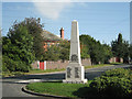
Exhall War Memorial, CV7
A modest unpolished pale granite obelisk, it stands on a traffic island at the junction of St Giles Road, foreground, Vicarage Road, right, and Church Lane beyond (which is mostly in the next square). The house is believed to be the vicarage of nearby St Giles Church Image
The obeliskal form of memorial was sometimes preferred by communities because it was non-denominational and even non-Christian. The inscriptions in view relate to the Second World War; the First World War commemorations are on the opposite side. Newspaper reports of Remembrance services in the 1940s and 50s don't mention Exhall or Ash Green but they do mention Keresley, 2.5km to the west, and Bedworth to the northeast, in connection with Remembrance events.
Image: © Robin Stott
Taken: 11 Oct 2010
0.02 miles
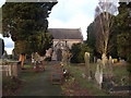
6
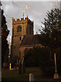
St Giles Church, Ash Green
As seen from the walkway behind the church.
Image: © Niki Walton
Taken: 29 Dec 2018
0.03 miles
7
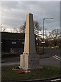
War Memorial, Ash Green
On a small traffic island between St Giles Church and the Church Hall.
Image: © Niki Walton
Taken: 29 Dec 2018
0.03 miles
8
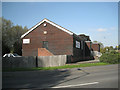
Church hall, St Giles Road, Exhall, CV7
The Breach Brook runs between willows beside the car park at the back. The hall faces Vicarage Road. This is the main hall; there is a small hall near the church, behind the camera. This area is also referred to as Ash Green.
Image: © Robin Stott
Taken: 11 Oct 2010
0.03 miles
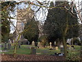
10
St Giles Church and Churchyard
Looking along a wide pathway towards the church from an alleyway which goes around the back of the church. There are gates to the pathway at this point, however the perimeter is currently home to stacked gravestones so no access is currently possible from here.
Image: © Niki Walton
Taken: 29 Dec 2018
0.03 miles