IMAGES TAKEN NEAR TO
Trelawney Road, COVENTRY, CV7 9FB
Introduction
This page details the photographs taken nearby to Trelawney Road, CV7 9FB by members of the Geograph project.
The Geograph project started in 2005 with the aim of publishing, organising and preserving representative images for every square kilometre of Great Britain, Ireland and the Isle of Man.

There are currently over 7.5m images from over14,400 individuals and you can help contribute to the project by visiting https://www.geograph.org.uk
Image Map
Images are licensed for reuse under creativecommons.org/licenses/by-sa/2.0
Notes
- Clicking on the map will re-center to the selected point.
- The higher the marker number, the further away the image location is from the centre of the postcode.
Image Listing (13 Images Found)
Images are licensed for reuse under creativecommons.org/licenses/by-sa/2.0
Image
Details
Distance
1
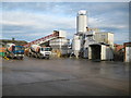
Exhall: Hanson Premix ready mixed concrete plant
The ready mixed concrete plant is on Bryant Road in the Bayton Road industrial estate.
Image: © Nigel Cox
Taken: 31 Dec 2011
0.08 miles
4

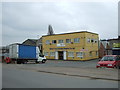
Gurdwara (Sikh temple), Bayton Road, Bedworth
Gurdwara on the Bayton Road industrial estate, in among the sheet metal and plastics factories. There is another gurdwara almost opposite, a modest single-storey building unadorned by a dome. The one photographed is called Gurdwara Baba Vadbhag Singh Ji.
Image: © A J Paxton
Taken: 30 May 2021
0.13 miles
5
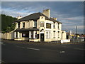
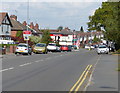
Exhall: The Lord Raglan
Judging by the state of the car park and the back yard the Raggy on the B4113 Coventry Road appears to now be closed.
Image: © Nigel Cox
Taken: 31 Dec 2011
0.15 miles
6
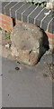
Old Milestone by former A444 (now B4113), Coventry Road, Bedworth
The Milestone is located against a low brick wall on the west of the road. Parish of Bedworth (Nuneaton and Bedworth District). Stone post (plate lost), erected by an unknown authority in the 18th Century.
Inscription reads:- (To / Coventry / IV Miles / To Hinkley / IX Miles)
Milestone Society National ID: WA_CVHY04
Image: © Jan O'Halloran
Taken: 10 Dec 2018
0.15 miles
7
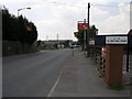
Bayton Road Industry
Bayton Road Industrial Estate is laid out in zones which are indicated by these very visible signs.
Image: © Michael Patterson
Taken: 3 Jul 2006
0.15 miles
9
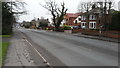
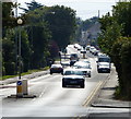
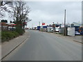
Coventry Road Exhall
Coventry Road is a main arterial route linking Bedworth with Coventry. Here it is photographed in Exhall, south of Bedworth.
Image: © Peter Mackenzie
Taken: 17 Jan 2017
0.18 miles