
IMAGES TAKEN NEAR TO
Grove Lane, COVENTRY, CV7 8PN
Introduction
This page details the photographs taken nearby to Grove Lane, CV7 8PN by members of the Geograph project.
The Geograph project started in 2005 with the aim of publishing, organising and preserving representative images for every square kilometre of Great Britain, Ireland and the Isle of Man.

There are currently over 7.5m images from over14,400 individuals and you can help contribute to the project by visiting https://www.geograph.org.uk
Image Map
Images are licensed for reuse under creativecommons.org/licenses/by-sa/2.0
Notes
- Clicking on the map will re-center to the selected point.
- The higher the marker number, the further away the image location is from the centre of the postcode.
Image Listing (16 Images Found)
Images are licensed for reuse under creativecommons.org/licenses/by-sa/2.0
Image
Details
Distance
1
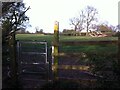
Kissing gate and footpath sign on path from Bennetts Road North towards M6 motorway bridge
The gate is located at the end of a straight and narrow section of path bounded by a fence separating it from houses and gardens to the right and to the left by a hedgerow with trees. The gate leads into a field with a distinctive fallen, dead tree, visible on the right hand side of the photo. The path follows the left-hand, north-western side of the field, off to the left of the picture, following the hedgerow and a stream.
Image: © A J Paxton
Taken: 26 Apr 2021
0.06 miles
2
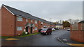
New houses on Miners Lane
A modern housing development on the outskirts of Keresley.
Image: © Peter Mackenzie
Taken: 20 Nov 2017
0.07 miles
5
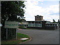
Keresley Newland Primary School
A 1950s style building near the southern edge of the square.
Image: © David Stowell
Taken: 27 Aug 2006
0.08 miles
6
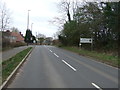
Entering Coventry
Heading south east on Bennett's Road North.
Image: © JThomas
Taken: 11 Mar 2017
0.10 miles
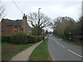
8
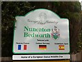
Keresley End - still European after all these years
This sign stands on the northern edge of Keresley End (known to the Ordnance Survey as Keresley Newlands), the former mining village attached to Coventry Colliery. The sign is situated on Bennetts Road North, which at this point forms the boundary between the city of Coventry and the borough of Nuneaton & Bedworth.
The European Status Wildlife Site sign refers to Ensors Pool, which since Brexit no longer comes under the remit of the European Union and its directives, and which has lost the crayfish population which gave it European status as a wildlife site; see here Image
George Eliot was born nearby, as Mary Ann Evans, on the Arbury Estate, see Image
Image: © A J Paxton
Taken: 17 May 2020
0.12 miles
9
Littlehurst Nursery and Garden Centre
On Bennett's Road North, Corley.
Image: © JThomas
Taken: 11 Mar 2017
0.12 miles
10
Littlehurst Nurseries, Bennetts Rd North, Keresley
Also see David Stowell's photo Image], taken almost exactly 4 years earlier. Little seems to have changed -even the red van is in the same position!
Image: © John Brightley
Taken: 31 Aug 2010
0.12 miles