
IMAGES TAKEN NEAR TO
Ansley Lane, COVENTRY, CV7 8FU
Introduction
This page details the photographs taken nearby to Ansley Lane, CV7 8FU by members of the Geograph project.
The Geograph project started in 2005 with the aim of publishing, organising and preserving representative images for every square kilometre of Great Britain, Ireland and the Isle of Man.

There are currently over 7.5m images from over14,400 individuals and you can help contribute to the project by visiting https://www.geograph.org.uk
Image Map
Images are licensed for reuse under creativecommons.org/licenses/by-sa/2.0
Notes
- Clicking on the map will re-center to the selected point.
- The higher the marker number, the further away the image location is from the centre of the postcode.
Image Listing (9 Images Found)
Images are licensed for reuse under creativecommons.org/licenses/by-sa/2.0
Image
Details
Distance
1

Bungalow and House on Church Lane as it climbs to Old Arley
Image: © Mick Malpass
Taken: 1 Apr 2012
0.13 miles
2
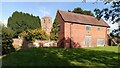
Old Arley with church tower
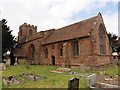
So named to distinguish it from the neighbouring mining village of New Arley, Old Arley predates the modern coal industry by centuries. St Wilfrid's church was built in the 14th century and was restored in 1873; see the listing at the Historic England site https://historicengland.org.uk/listing/the-list/list-entry/1034773?section=official-list-entry .
Image: © A J Paxton
Taken: 17 Oct 2023
0.18 miles
4
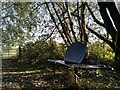
South Eastern gate to Arley Wood, with snail bench
The bench was installed on the route of an Arley parish walk, an offshoot of a longer North Warwickshire Heritage Trail. It carries a couplet from the poem 'Leisure', by the Welsh poet and tramp W H Davies. The whole poem can be seen at his Wikipedia entry https://en.m.wikipedia.org/wiki/W._H._Davies ; for the footpaths, see the North Warwickshire council site https://www.northwarks.gov.uk/download/downloads/id/8388/arley_parish_walk.pdf .
Image: © A J Paxton
Taken: 17 Oct 2023
0.19 miles
5
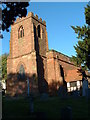
St. Wilfrid's Church, Old Arley
The church where my wife and I got married on 9th July 2005.
Image: © Richard Harrison
Taken: 4 Oct 2004
0.19 miles
6
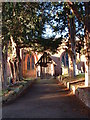
The door to the rest of my life
The front door to St. Wilfrid's church, Old Arley.
Image: © Richard Harrison
Taken: 4 Oct 2004
0.19 miles
7
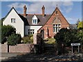
Former village school, Old Arley
Arley acquired a free school in 1875, according to Wikipedia https://en.m.wikipedia.org/wiki/Old_Arley ; this was presumably the building, now converted into housing.
Image: © A J Paxton
Taken: 17 Oct 2023
0.20 miles
8
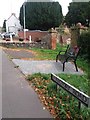
Commemorative Bench, Old Arley
Recent addition near to WWI/II commemoration. The bench has outline of soldiers and poppies on it.
Image: © Michael Westley
Taken: 16 Sep 2018
0.21 miles
9
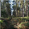
Path through Arley Wood
The ancient Arley Wood was turned into a conifer plantation in the 1960s, with a great loss of wildlife; note the ranks of trees of a single species and the dense undergrowth of bracken. It is now slowly being replanted with native broadleaved species such as oak. See Image] and Image
Though the loss is greatly to be regretted, it remains a peaceful place, beautiful in its way, the rustling of the trees blotting out human noise, apart from the occasional passing of aircraft overhead or the hooting of a train on the nearby railway.
Image: © A J Paxton
Taken: 17 Oct 2023
0.24 miles