IMAGES TAKEN NEAR TO
Lawrence Court, COVENTRY, CV7 8FB
Introduction
This page details the photographs taken nearby to Lawrence Court, CV7 8FB by members of the Geograph project.
The Geograph project started in 2005 with the aim of publishing, organising and preserving representative images for every square kilometre of Great Britain, Ireland and the Isle of Man.

There are currently over 7.5m images from over14,400 individuals and you can help contribute to the project by visiting https://www.geograph.org.uk
Image Map
Images are licensed for reuse under creativecommons.org/licenses/by-sa/2.0
Notes
- Clicking on the map will re-center to the selected point.
- The higher the marker number, the further away the image location is from the centre of the postcode.
Image Listing (4 Images Found)
Images are licensed for reuse under creativecommons.org/licenses/by-sa/2.0
Image
Details
Distance
1
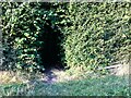
Into the woods by Red Hill Farm
The footpath, which is part of the Coventry Way, enters the wood through this arch of foliage. There is a small bench to the right, offering a view across a meadow. The wood appears to be of recent origin; it is not marked on OS maps as late as the 1950s.
Image: © A J Paxton
Taken: 6 Sep 2021
0.12 miles
2
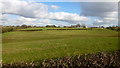
Pastoral scene east of Fillongley
Rowes House and Rose Farm can be seen across the fields.
Image: © Jonathan Billinger
Taken: 7 Feb 2017
0.21 miles
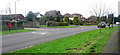
3

Coventry Road, Fillongley, 1
The B4098, looking towards Coventry, on bin day.
Image: © Jonathan Billinger
Taken: 7 Feb 2017
0.21 miles
4
The B4098 on its way north west to Fillongley
Image: © Keith Williams
Taken: 20 Feb 2007
0.22 miles