IMAGES TAKEN NEAR TO
Berryfields, COVENTRY, CV7 8EX
Introduction
This page details the photographs taken nearby to Berryfields, CV7 8EX by members of the Geograph project.
The Geograph project started in 2005 with the aim of publishing, organising and preserving representative images for every square kilometre of Great Britain, Ireland and the Isle of Man.

There are currently over 7.5m images from over14,400 individuals and you can help contribute to the project by visiting https://www.geograph.org.uk
Image Map
Images are licensed for reuse under creativecommons.org/licenses/by-sa/2.0
Notes
- Clicking on the map will re-center to the selected point.
- The higher the marker number, the further away the image location is from the centre of the postcode.
Image Listing (7 Images Found)
Images are licensed for reuse under creativecommons.org/licenses/by-sa/2.0
Image
Details
Distance
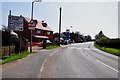
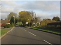
2
Greens Farm on the junction of the B4102 Nuneaton Road and Berryfields
Image: © Mick Malpass
Taken: 1 Apr 2012
0.10 miles
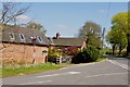
4
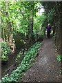
Quaint footpath, Fillongley
Footpath and right of way between Nuneaton Road and Church Road, Fillongley
Image: © Michael Westley
Taken: 19 May 2019
0.15 miles
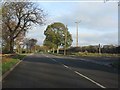
5
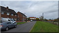
Nuneaton Road, Fillongley
Local authority housing in Fillongley.
Image: © Peter Mackenzie
Taken: 3 Nov 2018
0.19 miles