IMAGES TAKEN NEAR TO
Riddings Hill, COVENTRY, CV7 7RA
Introduction
This page details the photographs taken nearby to Riddings Hill, CV7 7RA by members of the Geograph project.
The Geograph project started in 2005 with the aim of publishing, organising and preserving representative images for every square kilometre of Great Britain, Ireland and the Isle of Man.

There are currently over 7.5m images from over14,400 individuals and you can help contribute to the project by visiting https://www.geograph.org.uk
Image Map
Images are licensed for reuse under creativecommons.org/licenses/by-sa/2.0
Notes
- Clicking on the map will re-center to the selected point.
- The higher the marker number, the further away the image location is from the centre of the postcode.
Image Listing (60 Images Found)
Images are licensed for reuse under creativecommons.org/licenses/by-sa/2.0
Image
Details
Distance
1
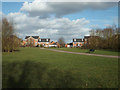
Footpath to Grovefield Crescent, Lavender Hall Park, Balsall Common
The park is better-connected to the new residential estate off Hallmeadow Road than to the older part of the village behind the camera. The estate and the park followed the construction of the road in the late 1990s.
Image: © Robin Stott
Taken: 27 Feb 2015
0.09 miles
2
Path to Huggins Close, southeast end of Lavender Hall Park, Balsall Common
Rounding a corner at the end of Green Lane this spacious park came into view – a complete surprise. The path cuts through one of the retained hedgerows.
Image: © Robin Stott
Taken: 27 Feb 2015
0.10 miles
4
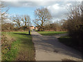
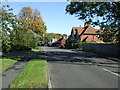
Hallmeadow Road meets Station Road CV7
Relatively new Hallmeadow Road, left, may relieve the (mostly residential) A452 Kenilworth Road through Balsall Common, but it's only half a bypass.
Image: © Robin Stott
Taken: 21 Jan 2011
0.11 miles
5
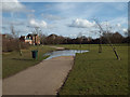
A rather big puddle, Lavender Hall Park, Balsall Common
Imperceptible falls must cause all the rainfall to gather here. During my visit the ground seemed rather soggy, perhaps due to the level terrain and a rather impermeable soil. The trees may have been pushed over by vandals; soft ground will have made the job easier. Putting in drainage at this stage, or even changing the levels locally, would be disruptive but could have benefits for users of this fine new park.
Image: © Robin Stott
Taken: 27 Feb 2015
0.11 miles
6
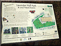
One of the interpretive signs, Lavender Hall Park, Balsall Common
The location is seen in Image The 11-hectare park became public open space in 2000. It is owned and managed by Solihull Metropolitan Borough Council. It is not known whether this splendid amenity was provided by planning agreement linked to other development in the village.
Image: © Robin Stott
Taken: 27 Feb 2015
0.12 miles
7
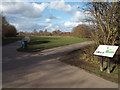
Junction of paths, southeast corner of Lavender Hall Park
The interpretive sign is the subject of Image It faces visitors who enter the park from Green Lane.
Image: © Robin Stott
Taken: 27 Feb 2015
0.12 miles
9
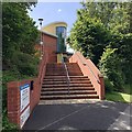
Steps from Hallmeadow Road to Balsall Common Health Centre
The centre is home to the Balsall Common and Meriden Group Practice, Community Services, and Balsall Common Dental Care. When I photographed the centre in 2015 (not yet uploaded) it seemed brand new. There was a Lloyds Pharmacy in the building too.
Image: © Robin Stott
Taken: 22 Jun 2019
0.13 miles
10
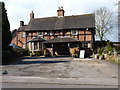
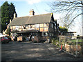
The Brickmaker's Arms
Grade II listed https://www.britishlistedbuildings.co.uk/101367067-the-brickmakers-arms-public-house-berkswell#.WrqOhtQrLGg in 1976, the pub dates back to the 17th century, and was probably a farmhouse originally. The porch on the front is a modern addition.
Image: © Richard Law
Taken: 21 Mar 2018
0.13 miles