IMAGES TAKEN NEAR TO
Centenary Drive, COVENTRY, CV7 7PW
Introduction
This page details the photographs taken nearby to Centenary Drive, CV7 7PW by members of the Geograph project.
The Geograph project started in 2005 with the aim of publishing, organising and preserving representative images for every square kilometre of Great Britain, Ireland and the Isle of Man.

There are currently over 7.5m images from over14,400 individuals and you can help contribute to the project by visiting https://www.geograph.org.uk
Image Map
Images are licensed for reuse under creativecommons.org/licenses/by-sa/2.0
Notes
- Clicking on the map will re-center to the selected point.
- The higher the marker number, the further away the image location is from the centre of the postcode.
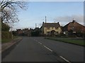
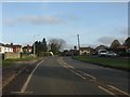
Image Listing (43 Images Found)
Images are licensed for reuse under creativecommons.org/licenses/by-sa/2.0
Image
Details
Distance
3
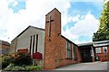
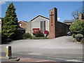
Meriden Methodist Church, Main Road, Meriden
Image: © Ann Causer
Taken: Unknown
0.14 miles
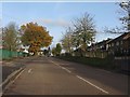
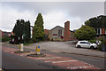
4
Leys Lane, Meriden
Looking towards the junction with Main Road at the eastern end of the village.
Image: © Stephen McKay
Taken: 1 Dec 2008
0.15 miles
8
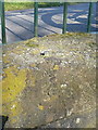
OS rivet - Meriden duckpond culvert
An OS rivet dating from 1957 on the upper stone of the culvert that drains the pond; originally levelled at 107.184m above Ordnance Datum Newlyn.
Image: © Richard Law
Taken: 7 Mar 2016
0.17 miles