IMAGES TAKEN NEAR TO
Rushton Close, COVENTRY, CV7 7PA
Introduction
This page details the photographs taken nearby to Rushton Close, CV7 7PA by members of the Geograph project.
The Geograph project started in 2005 with the aim of publishing, organising and preserving representative images for every square kilometre of Great Britain, Ireland and the Isle of Man.

There are currently over 7.5m images from over14,400 individuals and you can help contribute to the project by visiting https://www.geograph.org.uk
Image Map
Images are licensed for reuse under creativecommons.org/licenses/by-sa/2.0
Notes
- Clicking on the map will re-center to the selected point.
- The higher the marker number, the further away the image location is from the centre of the postcode.
Image Listing (48 Images Found)
Images are licensed for reuse under creativecommons.org/licenses/by-sa/2.0
Image
Details
Distance
2
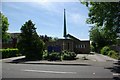
Station Road, Balsall Common CV7
The northern section of the road, heading for the station. The needle-like spire of the Methodist Church can be seen on the right.
Image: © Robin Stott
Taken: 21 Jan 2011
0.09 miles
4
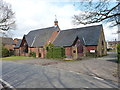
Catholic church in Balsall Common
The Catholic Church of Blessed Robert Grissold sits on Meeting House Lane.
Image: © Richard Law
Taken: 21 Mar 2018
0.11 miles
5
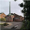
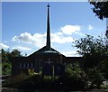
Methodist church, Balsall Common
This otherwise very plain suburban church has a striking spire.
Image: © A J Paxton
Taken: 10 Oct 2023
0.11 miles
6
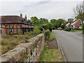
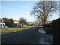
Southeast on Barretts Lane, Balsall Common
On the left is the former Sunnyside Farm; some derelict outbuildings remain. The timber-framed house appears to have been divided and refronted as cottages. The brick wall is capped with massive blocks of red stone, probably the Permian sandstone from Kenilworth. Houses on the right are typical of Balsall Common, a large commuter village that grew from an Arden hamlet after the coming of the railway. Berkswell station on the Coventry-Birmingham line was built to serve ancient Berkswell village to the north. Commuters and freight are also served by the A452 through the village.
Image: © Robin Stott
Taken: 30 Apr 2017
0.11 miles
9
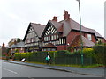
Large House in Berkswell
This apparently modern large detached house on the south side of Station Road has written in large letters across the front Berkswell Village stores. It appears to have no garden to the rear, only another large house built in close proximity.
Image: © Nigel Mykura
Taken: 20 Nov 2012
0.13 miles
10
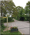
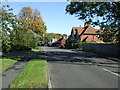
Suburbia meets countryside, Barretts Lane, Balsall Common
The lane continues as a public footpath. The turnings left and right are private drives. On the right beyond the drive is the entry to a meadow, church land seemingly and de facto open space. On the left a footpath goes north into the tangle of lanes and paths to the west of Coventry – Arden countryside.
Image: © Robin Stott
Taken: 30 Apr 2017
0.13 miles