IMAGES TAKEN NEAR TO
Blythe Avenue, COVENTRY, CV7 7GN
Introduction
This page details the photographs taken nearby to Blythe Avenue, CV7 7GN by members of the Geograph project.
The Geograph project started in 2005 with the aim of publishing, organising and preserving representative images for every square kilometre of Great Britain, Ireland and the Isle of Man.

There are currently over 7.5m images from over14,400 individuals and you can help contribute to the project by visiting https://www.geograph.org.uk
Image Map
Images are licensed for reuse under creativecommons.org/licenses/by-sa/2.0
Notes
- Clicking on the map will re-center to the selected point.
- The higher the marker number, the further away the image location is from the centre of the postcode.
Image Listing (11 Images Found)
Images are licensed for reuse under creativecommons.org/licenses/by-sa/2.0
Image
Details
Distance
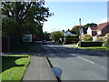
1
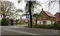
Blythe Avenue
A typical residential road in Balsall Common consisting mainly of bungalows. The road at the far end is Malvern Rd.
Image: © Nigel Mykura
Taken: 11 Feb 2012
0.04 miles
4
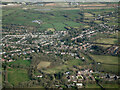
HS2 construction site near Balsall Common from the air
Balsall Common is in the foreground, with the HS2 works in the distance. Viewed from a Birmingham bound flight from Prague.
Image: © Thomas Nugent
Taken: 11 Feb 2022
0.10 miles
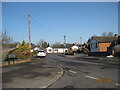
5
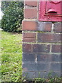
OS benchmark - Balsall Common, postbox at road junction
An OS cutmark on the brick pillar containing a George V wallbox. It was originally levelled, almost certainly in 1966, at 123.430m above Ordnance Datum Newlyn.
Image: © Richard Law
Taken: 21 Mar 2018
0.12 miles
6
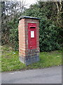
George V post box at the road junction
Post box CV7 113D, a George V wallbox which would have been manufactured around 1933 by Derby Castings, and was presumably installed at the same time.
Image: © Richard Law
Taken: 21 Mar 2018
0.12 miles
7
Main entrance to the new Elysian Gardens estate, Kenilworth Road, Balsall Common
A satellite photo shows the estate wrapping round a spacious older development to present two frontages to Kenilworth Road. Mature trees including old hedgerow oaks lend dignity to the boxes.
Image: © Robin Stott
Taken: 30 Apr 2017
0.16 miles
8
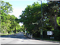
Kenilworth Road A452
At the busy junction with Alder Lane / Kelsey Lane B4101, at the southeastern edge of Balsall Common. Many of the trees will be old hedgerow oaks absorbed into suburban development.
Image: © Robin Stott
Taken: 22 May 2010
0.18 miles
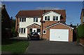
9
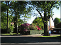
Detached houses, Kenilworth Road
Old hedgerow oaks adapt to suburban life, forming its setting alongside 20th century garden planting: silver birch, rhododendrons, privet and laburnum.
Image: © Robin Stott
Taken: 22 May 2010
0.18 miles
10
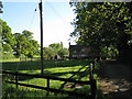
Rosalyn Cottage, Kenilworth Road
On the very edge of suburban Balsall Common and perhaps earlier than it.
Image: © Robin Stott
Taken: 22 May 2010
0.22 miles