IMAGES TAKEN NEAR TO
Waste Lane, COVENTRY, CV7 7GH
Introduction
This page details the photographs taken nearby to Waste Lane, CV7 7GH by members of the Geograph project.
The Geograph project started in 2005 with the aim of publishing, organising and preserving representative images for every square kilometre of Great Britain, Ireland and the Isle of Man.

There are currently over 7.5m images from over14,400 individuals and you can help contribute to the project by visiting https://www.geograph.org.uk
Image Map
Images are licensed for reuse under creativecommons.org/licenses/by-sa/2.0
Notes
- Clicking on the map will re-center to the selected point.
- The higher the marker number, the further away the image location is from the centre of the postcode.
Image Listing (14 Images Found)
Images are licensed for reuse under creativecommons.org/licenses/by-sa/2.0
Image
Details
Distance
1
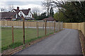
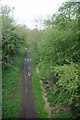
Temporary Kenilworth Greenway
In order to accommodate HS2 construction work the Kenilworth Greenway has been temporarily diverted following a new route across fields. Here, it winds its way around houses on Waste Lane and has, for a very short distance, an asphalt surface.
Image: © Stephen McKay
Taken: 14 Apr 2021
0.01 miles
2
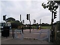
The diverted Greenway crosses Waste Lane at Catchems Corner
And no expense has been spared by HS2, the cause of the diversion. A Toucan crossing, gates, even a mounting block for horse and pony riders. It is a refreshing change to see pedestrians and cyclists (and equestrians) treated so generously, but it is not hard to see why the high speed railway has gone vastly over budget if this largesse has been repeated all the way from Birmingham to London. There is a similar crossing at Burton Green which is temporary, as the completed work there is to include a tunnel under the road for the Greenway.
The 87 bus from Coventry to Solihull is approaching from the left.
Image: © A J Paxton
Taken: 10 Oct 2023
0.03 miles
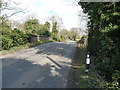
3
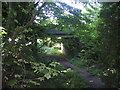
Waste Lane Bridge
Carrying Waste Lane over the trackbed of the Kenilworth Junction to Berkswell line. This line provided a useful bypass for the congested junction in Coventry and various plans have come and gone over the years for its re-instatement.
Image: © David Stowell
Taken: 21 Aug 2005
0.12 miles
4
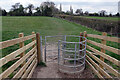
Footpath to Old Waste Lane
A new gate and fence have been provided giving access to the path from the temporary Kenilworth Greenway. Even so, the course of the path is only faintly discernible across the field.
Image: © Stephen McKay
Taken: 14 Apr 2021
0.13 miles
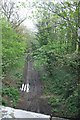
5
Disused railway from the Waste Lane bridge
Image: © Keith Williams
Taken: 2 May 2008
0.14 miles
6
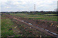
HS2 works, north-west of Waste Lane
Construction of the High Speed 2 (HS2) line is taking place, at this point using the alignment of the old Berkswell Loop railway.
Image: © Stephen McKay
Taken: 14 Apr 2021
0.14 miles
7
Waste Lane railway bridge
Waste Lane crosses the disused Kenilworth Junction to Berkswell railway, which was built in the 1880s by the LNWR, and then removed by the end of the 1960s.
Image: © Richard Law
Taken: 21 Mar 2018
0.15 miles
8
Disused railway from the Waste Lane bridge
Image: © Keith Williams
Taken: 2 May 2008
0.16 miles
9
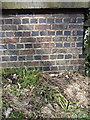
OS benchmmark, Catchems Corner, Waste Lane railway bridge
An OS cutmark on the parapet wall of the bridge over the disused railway, which was originally levelled in 1966, at 129.924m above Ordnance Datum Newlyn.
Image: © Richard Law
Taken: 21 Mar 2018
0.16 miles
10
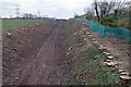
HS2 works, south-east of Waste Lane
On this stretch the High Speed 2 railway (HS2) will follow the alignment of the Berkswell loop line closed in 1969. This is the view from Waste Lane bridge towards Burton Green.
Image: © Stephen McKay
Taken: 14 Apr 2021
0.17 miles