IMAGES TAKEN NEAR TO
Green Lane, COVENTRY, CV7 7EJ
Introduction
This page details the photographs taken nearby to Green Lane, CV7 7EJ by members of the Geograph project.
The Geograph project started in 2005 with the aim of publishing, organising and preserving representative images for every square kilometre of Great Britain, Ireland and the Isle of Man.

There are currently over 7.5m images from over14,400 individuals and you can help contribute to the project by visiting https://www.geograph.org.uk
Image Map
Images are licensed for reuse under creativecommons.org/licenses/by-sa/2.0
Notes
- Clicking on the map will re-center to the selected point.
- The higher the marker number, the further away the image location is from the centre of the postcode.
Image Listing (54 Images Found)
Images are licensed for reuse under creativecommons.org/licenses/by-sa/2.0
Image
Details
Distance
1
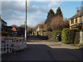
North on Green Lane, Balsall Common
Green Lane off the north side of Station Road appears to be a residential road not adopted by the highway authority, in other words a shared private access. Other services are present.
Image: © Robin Stott
Taken: 27 Feb 2015
0.03 miles
2
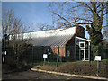
Balsall Common Public Library
Seen from the free car park at the back.
Image: © Robin Stott
Taken: 21 Jan 2011
0.05 miles
3
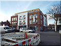
Flats above a Tesco Express, Station Road, Balsall Common
I don't remember this from previous visits to Balsall Common. Indeed, the 1:10k mapping and a superb aerial photo show this as a vacant site. How many local shops will this glorified convenience store put out of business?
To the right of it is the access to a free public car park, whence one may visit a community hall or the public library that fronts Kenilworth Road A452.
John Brightley adds "Yes, you are correct -the building was completed about 6 months ago [perhaps January 2015]. It replaced a couple of shops with flats above which were built in about the 1930's. I wish I'd got a photo of them before they were demolished."
Image: © Robin Stott
Taken: 27 Feb 2015
0.05 miles
4
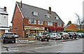
La Delicia and Masala Club, Station Road, Balsall Common, near Solihull
La Delicia at no. 231 is a continental delicatessen and café. Next door at no. 235 is Masala Club. This is not a private club but an Indian restaurant which also offers a takeaway service. The building itself straddles two OS squares but the majority of it is in SP2477.
Image: © P L Chadwick
Taken: 30 Dec 2013
0.06 miles
5
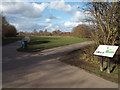
Junction of paths, southeast corner of Lavender Hall Park
The interpretive sign is the subject of Image It faces visitors who enter the park from Green Lane.
Image: © Robin Stott
Taken: 27 Feb 2015
0.06 miles
6
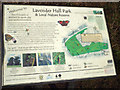
One of the interpretive signs, Lavender Hall Park, Balsall Common
The location is seen in Image The 11-hectare park became public open space in 2000. It is owned and managed by Solihull Metropolitan Borough Council. It is not known whether this splendid amenity was provided by planning agreement linked to other development in the village.
Image: © Robin Stott
Taken: 27 Feb 2015
0.06 miles
8
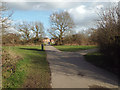
Path to Huggins Close, southeast end of Lavender Hall Park, Balsall Common
Rounding a corner at the end of Green Lane this spacious park came into view – a complete surprise. The path cuts through one of the retained hedgerows.
Image: © Robin Stott
Taken: 27 Feb 2015
0.06 miles
9
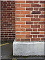
OS benchmark - Balsall Common, 299 Kenilworth Road
A clear OS cutmark on the front wall of an office building at the crossroads in the centre of Balsall Common; it was originally levelled, probably in 1966, at 122.960m above Ordnance Datum Newlyn.
Image: © Richard Law
Taken: 22 Aug 2017
0.07 miles
10
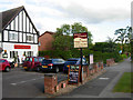
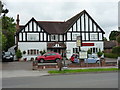
Haigs Hotel, Balsall Common
Independent family-run hotel on Kenilworth Road.
Image: © Stephen McKay
Taken: 13 Jun 2011
0.07 miles