
IMAGES TAKEN NEAR TO
Tallants Road, COVENTRY, CV6 7FQ
Introduction
This page details the photographs taken nearby to Tallants Road, CV6 7FQ by members of the Geograph project.
The Geograph project started in 2005 with the aim of publishing, organising and preserving representative images for every square kilometre of Great Britain, Ireland and the Isle of Man.

There are currently over 7.5m images from over14,400 individuals and you can help contribute to the project by visiting https://www.geograph.org.uk
Image Map
Images are licensed for reuse under creativecommons.org/licenses/by-sa/2.0
Notes
- Clicking on the map will re-center to the selected point.
- The higher the marker number, the further away the image location is from the centre of the postcode.
Image Listing (100 Images Found)
Images are licensed for reuse under creativecommons.org/licenses/by-sa/2.0
Image
Details
Distance
1
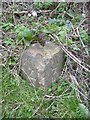
Old milemarker by Foleshill, Coventry
Milemarker by the Coventry Canal, in parish of Coventry (Coventry District), Foleshill, 220m North of Bridge No 6 in grass.
Inscription reads:-
: 4 : : 3 :
Carved bench mark on right face.
Surveyed
Milestone Society National ID: COV-03
Image: © Milestone Society
Taken: Unknown
0.11 miles
2
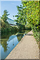
Coventry Canal
A section of the Coventry Canal, with Gallagher Retail Park on the left, built on the site of the Alfred Herbert machine tool factory, in its heydey in the first half 20th Century one of the largest such manufacturers in the world. However, following decline and various takeovers it eventually ceased operations in 1983.
Image: © Ian Capper
Taken: 23 Sep 2021
0.12 miles
3
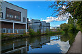
Coventry : Coventry Canal
Looking along Coventry Canal.
Image: © Lewis Clarke
Taken: 25 Sep 2021
0.12 miles
4
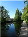
Coventry Canal
Passing through Foleshill.
Image: © Anne Burgess
Taken: 23 Sep 2021
0.13 miles
5
![A stroll along the Coventry Canal to Hawkesbury Junction [22]](https://s3.geograph.org.uk/geophotos/07/12/19/7121939_7cbc2fab_120x120.jpg)
A stroll along the Coventry Canal to Hawkesbury Junction [22]
Seen across the canal are buildings of the Gallagher Retail Park.
The narrow canal was built to connect the city of Coventry with the Trent & Mersey Canal, some 38 miles distant, to exploit the Warwickshire coalfields. Construction of the canal took 20 years before it was complete in 1769. The canal between the basin in Coventry and Hawkesbury junction was made a conservation area in 2012.
Image: © Michael Dibb
Taken: 23 Sep 2021
0.13 miles
6
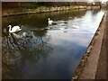
Swans on the Coventry Canal
Near to the Gallagher retail park.
Image: © A J Paxton
Taken: 21 Mar 2019
0.13 miles
7
![A stroll along the Coventry Canal to Hawkesbury Junction [23]](https://s0.geograph.org.uk/geophotos/07/12/19/7121940_db0b7a42_120x120.jpg)
A stroll along the Coventry Canal to Hawkesbury Junction [23]
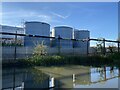
Seen across the canal, these tanks are part of the Godiva Trading Estate.
The narrow canal was built to connect the city of Coventry with the Trent & Mersey Canal, some 38 miles distant, to exploit the Warwickshire coalfields. Construction of the canal took 20 years before it was complete in 1769. The canal between the basin in Coventry and Hawkesbury junction was made a conservation area in 2012.
Image: © Michael Dibb
Taken: 23 Sep 2021
0.13 miles
10
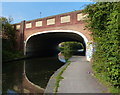
Bridge 6A: Phoenix Way
Carrying the A444 across the Coventry Canal.
Image: © Mat Fascione
Taken: 11 Sep 2014
0.14 miles