IMAGES TAKEN NEAR TO
Dudley Street, COVENTRY, CV6 7EJ
Introduction
This page details the photographs taken nearby to Dudley Street, CV6 7EJ by members of the Geograph project.
The Geograph project started in 2005 with the aim of publishing, organising and preserving representative images for every square kilometre of Great Britain, Ireland and the Isle of Man.

There are currently over 7.5m images from over14,400 individuals and you can help contribute to the project by visiting https://www.geograph.org.uk
Image Map
Images are licensed for reuse under creativecommons.org/licenses/by-sa/2.0
Notes
- Clicking on the map will re-center to the selected point.
- The higher the marker number, the further away the image location is from the centre of the postcode.
Image Listing (23 Images Found)
Images are licensed for reuse under creativecommons.org/licenses/by-sa/2.0
Image
Details
Distance
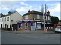
2
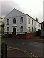
New Testament Church of God in former Wesleyan chapel building, Old Church Road, Foleshill
A Wesleyan chapel was built here in 1813. The present building dates from 1848 and was repaired after damage in the second world war. In the 1960s it was known as Bell Green Methodist Church (see Victoria County History, https://www.british-history.ac.uk/vch/warks/vol8/pp382-396 ). It is now home to a congregation of the New Testament Church of God.
Image: © A J Paxton
Taken: 27 Jul 2021
0.17 miles
3
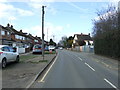
Cottages on Old Church Road, Foleshill
Coventry people generally associate Foleshill with the Foleshill Road, the historic main road north out of the city. The historic parish of Foleshill, however, was centred further east around Old Church Road, the old church in question being the parish church of St. Laurence, set back from the road in a wooded churchyard. The road itself still has a number of vernacular cottages and Victorian houses among the modern suburbia, as well as a 19th century Wesleyan chapel (not visible here). Old Church Road leads to Bell Green, and Dewis House, the tower block at Riley Square, can be seen in the distance.
Image: © A J Paxton
Taken: 27 Jul 2021
0.18 miles
4
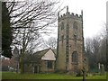
Coventry - Foleshill
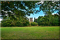
Church of St Laurence stands alone some distance from any road.
Image: © Ian Rob
Taken: 19 Feb 2006
0.19 miles
6
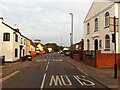
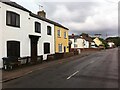
Old Church Road, Foleshill, looking towards Bell Green
With its vernacular cottages and village chapel this Coventry street looks almost rural, though the housing block in the distance, Dewis House in Riley Square, is definitely urban. See also Image] and Image
Image: © A J Paxton
Taken: 20 Jul 2022
0.19 miles
7
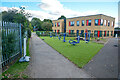
Coventry : Little Heath Primary School
A primary school on Old Church Road.
Image: © Lewis Clarke
Taken: 25 Sep 2021
0.20 miles
8
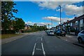
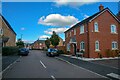
Coventry : Old Church Road B4082
Looking along Old Church Road.
Image: © Lewis Clarke
Taken: 25 Sep 2021
0.20 miles
9
Coventry : Cubbington Road Open Space
An open space for people to enjoy. St Laurence's can also be seen here.
Image: © Lewis Clarke
Taken: 25 Sep 2021
0.22 miles
10
Coventry : Lanchbury Avenue
Looking along the road off Old Church Road.
Image: © Lewis Clarke
Taken: 25 Sep 2021
0.22 miles