IMAGES TAKEN NEAR TO
Grindle Road, COVENTRY, CV6 6BS
Introduction
This page details the photographs taken nearby to Grindle Road, CV6 6BS by members of the Geograph project.
The Geograph project started in 2005 with the aim of publishing, organising and preserving representative images for every square kilometre of Great Britain, Ireland and the Isle of Man.

There are currently over 7.5m images from over14,400 individuals and you can help contribute to the project by visiting https://www.geograph.org.uk
Image Map (Loading...)


Getting Data...Please wait
Leaflet Map data © OpenStreetMap
Images are licensed for reuse under creativecommons.org/licenses/by-sa/2.0
Notes
- Clicking on the map will re-center to the selected point.
- The higher the marker number, the further away the image location is from the centre of the postcode.
Image Listing (93 Images Found)
Images are licensed for reuse under creativecommons.org/licenses/by-sa/2.0
Image
Details
Distance
1
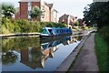
Canal boat Day Dream Believer, Coventry Canal
Image: © Ian S
Taken: 27 Aug 2019
0.03 miles
2
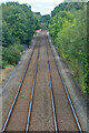
Coventry : Railway
The Coventry to Nuneaton line.
Image: © Lewis Clarke
Taken: 25 Sep 2021
0.04 miles
3

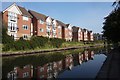
Coventry Canal
Looking along the Coventry Canal with housing in Grindle Road on the left, built on the site of the former Keresley Colliery Wharf.
Image: © Ian Capper
Taken: 23 Sep 2021
0.04 miles
4
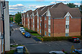
Houses on Grindle Road
Overlooking the Coventry Canal.
Image: © Ian S
Taken: 27 Aug 2019
0.04 miles
5
![A stroll along the Coventry Canal to Hawkesbury Junction [38]](https://s0.geograph.org.uk/geophotos/07/12/19/7121968_e7d16295_120x120.jpg)
A stroll along the Coventry Canal to Hawkesbury Junction [38]
Recently constructed housing seen across the canal.
The narrow canal was built to connect the city of Coventry with the Trent & Mersey Canal, some 38 miles distant, to exploit the Warwickshire coalfields. Construction of the canal took 20 years before it was complete in 1769. The canal between the basin in Coventry and Hawkesbury junction was made a conservation area in 2012.
Image: © Michael Dibb
Taken: 23 Sep 2021
0.05 miles
6
Coventry Canal
As the canal gets further from the city, it becomes more and more rural, flanked by housing rather than industrial and commercial buildings.
Image: © Anne Burgess
Taken: 23 Sep 2021
0.05 miles
7

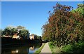
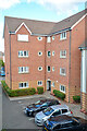
Coventry Canal, Longford
Seen from Judds Lane Bridge, the new flats are on Grindle Road.
Image: © Stephen McKay
Taken: 19 Oct 2008
0.05 miles
8
Coventry : Grindle Road
Looking along Grindle Road.
Image: © Lewis Clarke
Taken: 25 Sep 2021
0.06 miles
9
Coventry : Grindle Road
Looking towards a block of flats.
Image: © Lewis Clarke
Taken: 25 Sep 2021
0.06 miles
10
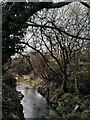
River Sowe, Longford Community Nature Park
The Sowe has just passed through a tunnel under Grindle Road and the Coventry Canal and is flowing eastwards towards Longford through a patch of floodplain that has been preserved as a nature park. The photographer is standing by the canal towpath.
Image: © A J Paxton
Taken: 22 Mar 2023
0.06 miles