IMAGES TAKEN NEAR TO
Bungalow Estate, Lady Lane, COVENTRY, CV6 6BD
Introduction
This page details the photographs taken nearby to Bungalow Estate, Lady Lane, CV6 6BD by members of the Geograph project.
The Geograph project started in 2005 with the aim of publishing, organising and preserving representative images for every square kilometre of Great Britain, Ireland and the Isle of Man.

There are currently over 7.5m images from over14,400 individuals and you can help contribute to the project by visiting https://www.geograph.org.uk
Image Map
Images are licensed for reuse under creativecommons.org/licenses/by-sa/2.0
Notes
- Clicking on the map will re-center to the selected point.
- The higher the marker number, the further away the image location is from the centre of the postcode.
Image Listing (129 Images Found)
Images are licensed for reuse under creativecommons.org/licenses/by-sa/2.0
Image
Details
Distance
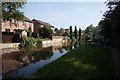
1
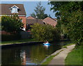
Towpath and houses along the Coventry Canal
Image: © Mat Fascione
Taken: 11 Sep 2014
0.04 miles
2
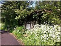
Coventry Canal towpath with Nissen hut
The rusting remains of a Nissen hut by the canal towpath in Longford, overgrown with elder and cow parsley.
Image: © A J Paxton
Taken: 1 Jun 2021
0.05 miles
3
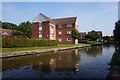
Flats on Grindle Road
Overlooking Coventry Canal.
Image: © Ian S
Taken: 27 Aug 2019
0.05 miles
4
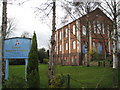
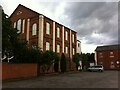
Coventry: Salem Baptist Church, Longford
This church is the third chapel to be built on the site on Lady Lane and dates from 1872. It is probably a locally, although not a nationally, listed building. The church's website is here http://www.salem-baptist-church.org.uk/index.shtml
Image: © Nigel Cox
Taken: 31 Dec 2011
0.06 miles
5
House of Empowerment, Longford
This has been the 'Empowerment Centre' of the House of Empowerment since 2016. This independent church meets in a building that was constructed as Salem Baptist Chapel in 1872. https://www.explorechurches.org/church/former-salem-baptist-chapel-longford
Image: © A J Paxton
Taken: 23 Aug 2020
0.06 miles
7
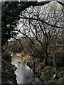
River Sowe, Longford Community Nature Park
The Sowe has just passed through a tunnel under Grindle Road and the Coventry Canal and is flowing eastwards towards Longford through a patch of floodplain that has been preserved as a nature park. The photographer is standing by the canal towpath.
Image: © A J Paxton
Taken: 22 Mar 2023
0.07 miles
8
Looking south-west from footbridge over the Coventry Canal
Image: © Ruth Sharville
Taken: 23 Sep 2021
0.08 miles
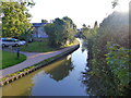
9

Coventry Canal
Looking along the Coventry Canal with housing in Grindle Road on the left, built on the site of the former Keresley Colliery Wharf.
Image: © Ian Capper
Taken: 23 Sep 2021
0.08 miles
10

The Stone Sofa
One of a series of sculptures along the towpath of the Coventry Canal - known as the Canal Art Trail. The artist was Tim Shutter and the sofa weighs 3.5 tonnes. More details are available at: http://www2.coventry.gov.uk/canalarttrail/artworks/u.htm .
Image: © Stephen McKay
Taken: 19 Oct 2008
0.08 miles