IMAGES TAKEN NEAR TO
The Croft, COVENTRY, CV6 6BA
Introduction
This page details the photographs taken nearby to The Croft, CV6 6BA by members of the Geograph project.
The Geograph project started in 2005 with the aim of publishing, organising and preserving representative images for every square kilometre of Great Britain, Ireland and the Isle of Man.

There are currently over 7.5m images from over14,400 individuals and you can help contribute to the project by visiting https://www.geograph.org.uk
Image Map
Images are licensed for reuse under creativecommons.org/licenses/by-sa/2.0
Notes
- Clicking on the map will re-center to the selected point.
- The higher the marker number, the further away the image location is from the centre of the postcode.
Image Listing (118 Images Found)
Images are licensed for reuse under creativecommons.org/licenses/by-sa/2.0
Image
Details
Distance
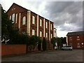
1
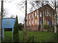
Coventry: Salem Baptist Church, Longford
This church is the third chapel to be built on the site on Lady Lane and dates from 1872. It is probably a locally, although not a nationally, listed building. The church's website is here http://www.salem-baptist-church.org.uk/index.shtml
Image: © Nigel Cox
Taken: 31 Dec 2011
0.06 miles
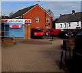
2
CMS Electrical Wholesales Ltd, Longford, Coventry
Set back from the west side of the B4113 Longford Road.
Image: © Jaggery
Taken: 19 Apr 2015
0.07 miles
3
Longford Dental Practice and Physio Fix, Coventry
Viewed across Longford Road. Longford Dental Practice on the left
and Physio Fix on the right are separated by Lady Lane.
Image: © Jaggery
Taken: 19 Apr 2015
0.07 miles
4
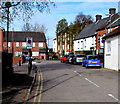
Longford Square, Longford, Coventry
From the Longford Road end looking towards Lady Lane. A sign on the left indicates
an Arena AD Zone - parking for permit holders only, during events shown on the sign.
Image: © Jaggery
Taken: 19 Apr 2015
0.07 miles
5
Spice Sensation, Longford, Coventry
Indian takeaway at 181B Longford Road in premises formerly occupied by Balti Express.
Image: © Jaggery
Taken: 19 Apr 2015
0.08 miles
6
House of Empowerment, Longford
This has been the 'Empowerment Centre' of the House of Empowerment since 2016. This independent church meets in a building that was constructed as Salem Baptist Chapel in 1872. https://www.explorechurches.org/church/former-salem-baptist-chapel-longford
Image: © A J Paxton
Taken: 23 Aug 2020
0.08 miles
7
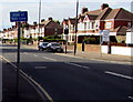
End of bus lane sign, Longford, Coventry
Alongside the B4113 Longford Road. Longford Dental Practice is on the right.
Image: © Jaggery
Taken: 19 Apr 2015
0.08 miles
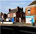
8
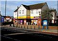
Longford Convenience Store, Coventry
Premier Store on the west side of Longford Road.
Image: © Jaggery
Taken: 19 Apr 2015
0.08 miles
9
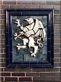
Terracotta gryphon, Longford Road, Coventry
This Delft ware gryphon is set into the wall of the Longford Primary Care Centre, a doctors' surgery built in a very plain modern style on a main road on the northern outskirts of Coventry. It is clearly a survivor of the Griffin or Old Griffin public house which once stood on or near this site; a photo on the Coventry's Pub History site shows the gryphon in situ on the front of the pub https://pubhistory.historiccoventry.co.uk/main/pub.php?pg=griffin_longford . A gryphon is a mythical beast that is part-eagle, part-lion.
Image: © A J Paxton
Taken: 11 Jul 2022
0.09 miles
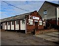
10
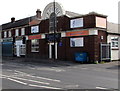
Capitol Gym, Longford, Coventry
The gym at 180 Longford Road is in a building that looks like a former cinema.
Image: © Jaggery
Taken: 19 Apr 2015
0.09 miles