IMAGES TAKEN NEAR TO
Albert Road, COVENTRY, CV5 9AS
Introduction
This page details the photographs taken nearby to Albert Road, CV5 9AS by members of the Geograph project.
The Geograph project started in 2005 with the aim of publishing, organising and preserving representative images for every square kilometre of Great Britain, Ireland and the Isle of Man.

There are currently over 7.5m images from over14,400 individuals and you can help contribute to the project by visiting https://www.geograph.org.uk
Image Map
Images are licensed for reuse under creativecommons.org/licenses/by-sa/2.0
Notes
- Clicking on the map will re-center to the selected point.
- The higher the marker number, the further away the image location is from the centre of the postcode.
Image Listing (17 Images Found)
Images are licensed for reuse under creativecommons.org/licenses/by-sa/2.0
Image
Details
Distance
1

Albert Road, Meriden
Housing built in the immediate vicinity of the former Triumph Motorcycles factory which was located just to the east of this estate Image; the housing was presumably built for the factory workers at the time.
Image: © Richard Law
Taken: 23 Aug 2018
0.01 miles
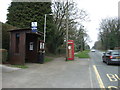
3
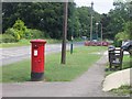
Georgian postbox in Millison's Wood
In the background can be seen the 'Welcome to Coventry' sign. The matching 'Welcome to Solihull' sign is by the roadworks on this side of the road.
Image: © Keith Williams
Taken: 19 Jun 2008
0.09 miles
4
Milepost in Millison's Wood
This road was originally the main route between Birmingham and Coventry, before the Meriden bypass, now the A45, was built in the 1930's.
Image: © Keith Williams
Taken: 19 Jun 2008
0.09 miles
5
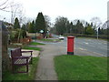
Birmingham Road (B4104)
Looking west showing position of Postbox No. CV5 241.
See Image] for postbox.
Image: © JThomas
Taken: 11 Mar 2017
0.09 miles
6
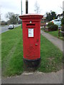
George VI postbox on Birmingham Road
Postbox No. CV5 241.
See Image] for context.
Image: © JThomas
Taken: 11 Mar 2017
0.09 miles
7
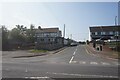
Birmingham Road east of Meriden
This is pretty much the opposing view to that seen in Image
Image: © Richard Law
Taken: 23 Aug 2018
0.10 miles
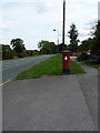
8
Bus stop and shelter on Birmingham Road (B4104)
Looking west.
Image: © JThomas
Taken: 11 Mar 2017
0.10 miles
9
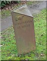
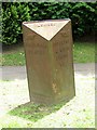
Old Milepost by the B4104, Birmingham Road, Meriden parish
Cast iron post by the B4104, in parish of MERIDEN (SOLIHULL District), Birmingham Road; by No. 25 Wellesbourne, West of phone box and bus stop, on grass verge between road and pavement, 7 feet from road, on South side of road. Grazebrook iron casting, erected by the County Council in the 19th century.
Inscription reads:-
: {hand->} / BIRMINGHAM / 13 MILES : : MERIDEN : : {<-hand} / COVENTRY / 4 MILES / LONDON / 95 :
Maker:-
: M&W GRAZEBROOK / IRONFOUNDERS / DUDLEY :
Milestone Society National ID: WA_CVBM04.
Image: © J & KS
Taken: 8 Oct 2002
0.10 miles
10

The Meriden milepost
Cast iron milepost from the days when the road through Meriden was the turnpiked main route between Coventry and Brum. Few of these remain in place on the route.
Image: © Richard Law
Taken: 23 Aug 2018
0.11 miles