IMAGES TAKEN NEAR TO
Duggins Lane, COVENTRY, CV4 9GP
Introduction
This page details the photographs taken nearby to Duggins Lane, CV4 9GP by members of the Geograph project.
The Geograph project started in 2005 with the aim of publishing, organising and preserving representative images for every square kilometre of Great Britain, Ireland and the Isle of Man.

There are currently over 7.5m images from over14,400 individuals and you can help contribute to the project by visiting https://www.geograph.org.uk
Image Map
Images are licensed for reuse under creativecommons.org/licenses/by-sa/2.0
Notes
- Clicking on the map will re-center to the selected point.
- The higher the marker number, the further away the image location is from the centre of the postcode.
Image Listing (12 Images Found)
Images are licensed for reuse under creativecommons.org/licenses/by-sa/2.0
Image
Details
Distance
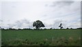
1
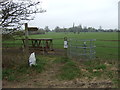
Footpath to nowhere, Reeves Green
Off Duggin's Lane.
Image: © JThomas
Taken: 11 Mar 2017
0.02 miles
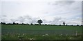
2
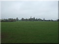
Grazing, Reeves Green
North of Duggin's Lane.
Image: © JThomas
Taken: 11 Mar 2017
0.05 miles
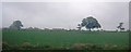
3
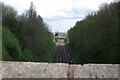
The railway line towards Coventry from the Nailcote Lane bridge
Image: © Keith Williams
Taken: 2 May 2008
0.09 miles
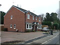
8
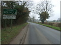
Entering Solihull
Heading south west on Duggin's Lane.
Image: © JThomas
Taken: 11 Mar 2017
0.21 miles
9
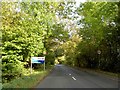
Welcome to Coventry
Coventry boundary sign on Duggins Lane.
Image: © Steve Fareham
Taken: 13 Oct 2009
0.22 miles
10
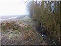
Tile Hill, ditch
Off Duggins Lane, and forming the boundary between Solihull and Coventry. The morning sun has not yet made an impression on the mist above the field.
Image: © Mike Faherty
Taken: 16 Feb 2013
0.23 miles