IMAGES TAKEN NEAR TO
Cromwell Lane, COVENTRY, CV4 8AP
Introduction
This page details the photographs taken nearby to Cromwell Lane, CV4 8AP by members of the Geograph project.
The Geograph project started in 2005 with the aim of publishing, organising and preserving representative images for every square kilometre of Great Britain, Ireland and the Isle of Man.

There are currently over 7.5m images from over14,400 individuals and you can help contribute to the project by visiting https://www.geograph.org.uk
Image Map
Images are licensed for reuse under creativecommons.org/licenses/by-sa/2.0
Notes
- Clicking on the map will re-center to the selected point.
- The higher the marker number, the further away the image location is from the centre of the postcode.
Image Listing (12 Images Found)
Images are licensed for reuse under creativecommons.org/licenses/by-sa/2.0
Image
Details
Distance
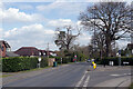
1
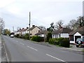
Cromwell Lane
Cromwell lane is one of the minor roads on the very south western fringe of suburban Coventry. It has been built up with bungalows and semi detached houses but on both side the houses back on to open fields.
Image: © Nigel Mykura
Taken: 6 Mar 2011
0.03 miles
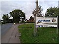
2
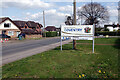
Entering Coventry
The large sign marks the boundary of the City of Coventry on Cromwell Lane. The strapline 'City of Peace and Reconciliation' refers back to the night in November 1940 when the cathedral and much of the city centre were destroyed by enemy action. Following that the Cathedral's provost urged people not to seek revenge, but to forgive. After the Second World War reconciliation links were set up with Dresden, Germany which had also suffered a devastating firebomb raid, and later Coventry was twinned with Hiroshima, Stalingrad, Lidice and Caen. In 2000 a Centre for the Study of Forgiveness and Reconciliation was established at Coventry University. At the bottom of the sign is a reminder that Coventry has been designated UK City of Culture for 2021.
Image: © Stephen McKay
Taken: 14 Apr 2021
0.07 miles
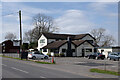
3
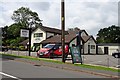
Burton Green-Hickory's Smoke House
Pub on Cromwell Road.
Image: © Ian Rob
Taken: 1 Aug 2019
0.08 miles
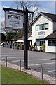
5
Hickory's Smokehouse, Burton Green
This pub on Cromwell Lane is one of a number around the country in the Hickory's chain, offering 'the southern tastes of America'. This view shows it in its previous incarnation as the 'Peeping Tom': Image
Image: © Stephen McKay
Taken: 14 Apr 2021
0.09 miles
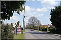
6
Welcome to the City of Coventry, Tile Hill
This sign, by the junction of Cromwell Lane and Westwood Heath Road, marks the boundary between Burton Green, a ribbon development suburb in Warwickshire, and Tile Hill in Coventry.
Image: © A J Paxton
Taken: 7 Oct 2023
0.09 miles
7
Hickory's Smokehouse, Burton Green
Under the Covid-19 restrictions in force at the time of this photograph, the pub on Cromwell Lane is open but only for outside service. Unfortunately, although the sun is shining the day could not be described as warm. See Image for a broader view.
Image: © Stephen McKay
Taken: 14 Apr 2021
0.09 miles
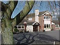
8
Cromwell Lane, Burton Green
Burton Green is a settlement that straggles along Cromwell Lane, just outside the boundary of the City of Coventry, with no real centre. There is a pub, now called Hickory's Smokehouse, which is on the left in this view. The sign says 'We're open outside' - this was the first week that pubs were allowed to open, for garden service only, after many months of closure due to the Covid-19 lockdown.
Image: © Stephen McKay
Taken: 14 Apr 2021
0.10 miles
9
Cromwell Lane, Tile Hill
This location is just inside the Coventry city boundary. Westwood Heath Road leads off to the right.
Image: © Stephen McKay
Taken: 14 Apr 2021
0.12 miles
10
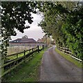
Westwood Farm, Cromwell Lane, Tile Hill
The western edge of Coventry is marked here by Cromwell Lane: on the eastern side, ribbon development housing, to the west, seen here, there is farmland between and behind the houses. The farm track is not a public right of way.
Image: © A J Paxton
Taken: 7 Oct 2023
0.20 miles