IMAGES TAKEN NEAR TO
Leighfield Road, COVENTRY, CV4 7EU
Introduction
This page details the photographs taken nearby to Leighfield Road, CV4 7EU by members of the Geograph project.
The Geograph project started in 2005 with the aim of publishing, organising and preserving representative images for every square kilometre of Great Britain, Ireland and the Isle of Man.

There are currently over 7.5m images from over14,400 individuals and you can help contribute to the project by visiting https://www.geograph.org.uk
Image Map
Images are licensed for reuse under creativecommons.org/licenses/by-sa/2.0
Notes
- Clicking on the map will re-center to the selected point.
- The higher the marker number, the further away the image location is from the centre of the postcode.
Image Listing (27 Images Found)
Images are licensed for reuse under creativecommons.org/licenses/by-sa/2.0
Image
Details
Distance
2
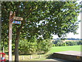
Route 52 to Kenilworth
Signposting for the footpath and cycleway to Kenilworth at its junction with Scarman Road on Warwick University campus. In the background is one of the university's sports pitches. Part of National Cycle Route 52.
Image: © E Gammie
Taken: 29 Sep 2013
0.08 miles
3
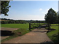
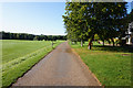
Pedestrian and cycle path near Scarman Road
National Cycle Route 52 passes Warwick University sports fields on its way towards Crackley from Scarman Road.
Image: © E Gammie
Taken: 29 Sep 2013
0.09 miles
4
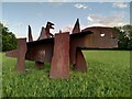
The Good, The Bad
The Good, The Bad, is a pair of dinosaurs made from corten steel by Jake and Dinos Chapman in 2007. This sculpture forms part of the University of Warwick art collection and can be seen at the southwestern, Cryfield Village end of the campus. See the Sculpture Park map at the university website https://warwick.ac.uk/services/art/sculpturepark/sculpture/for_screen_only_warwick_sculpture_map_artwork_file.pdf .
Image: © A J Paxton
Taken: 11 May 2023
0.09 miles
6
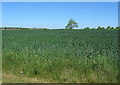
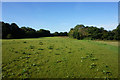
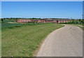
Roofs, tree, crop
The roofs of university residences, lone tree and growing crop at the edge of Warwick University campus.
Image: © E Gammie
Taken: 23 May 2010
0.12 miles
7
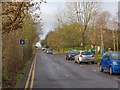
Scarman Road
A short road off Gibbet Hill Road, near Warwick University.
Image: © David P Howard
Taken: 4 Jan 2013
0.15 miles
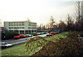
8
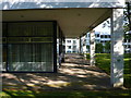
Benefactors Building University of Warwick
This is one of the earliest buildings on the campus dating from the 1960's. At one time there was a considerable problem with the white tiles falling off the buildings in large lumps. Behind can be seen a glimpse of Rootes student residence.
Image: © Nigel Mykura
Taken: 11 Jun 2011
0.20 miles
9
Warwick University: Benefactor's Hall, 1992
This was the second of Warwick's halls of residence, after Rootes. Opened in 1967, it has 46 rooms for undergraduates and was named after Helen Martin of Kenilworth, who during her life insisted on anonymity and was referred to by the university as "the benefactor". I took this picture on returning to Warwick for the 1966 intake's twenty-fifth anniversary reunion. The building's concrete frame was originally - like many of the University's first buildings - covered with white tiles (hence "white-tile" as an alternative name for the "plate-glass" universities new in the sixties), but is now clad in something else. Sixties students kicked up a fuss when it was discovered the tiles cost ten-bob (50p) each at a time when a gallon of petrol was 4/6 (22p).
Image: © John Sutton
Taken: 26 Jan 1992
0.20 miles
10
University buildings
University of Warwick student residences at the edge of campus.
Image: © E Gammie
Taken: 23 May 2010
0.21 miles