IMAGES TAKEN NEAR TO
Napton, SOUTHAM, CV47 8NF
Introduction
This page details the photographs taken nearby to CV47 8NF by members of the Geograph project.
The Geograph project started in 2005 with the aim of publishing, organising and preserving representative images for every square kilometre of Great Britain, Ireland and the Isle of Man.

There are currently over 7.5m images from over14,400 individuals and you can help contribute to the project by visiting https://www.geograph.org.uk
Image Map
Images are licensed for reuse under creativecommons.org/licenses/by-sa/2.0
Notes
- Clicking on the map will re-center to the selected point.
- The higher the marker number, the further away the image location is from the centre of the postcode.
Image Listing (17 Images Found)
Images are licensed for reuse under creativecommons.org/licenses/by-sa/2.0
Image
Details
Distance
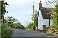
1
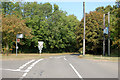
Triangle road junction at the top of Butt Hill
Image: © Andy F
Taken: 19 Sep 2009
0.02 miles
3
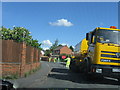
Spraying tar and laying chippings, Napton
Image: © Alex McGregor
Taken: 11 May 2010
0.04 miles
5
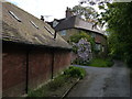
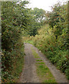
Lane in Napton on the Hill
The lane leads to the Church of St Lawrence and Napton Windmill.
Image: © Mat Fascione
Taken: 15 May 2015
0.07 miles
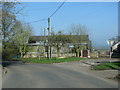
6
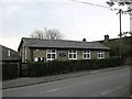
Napton On The Hill
The Old School Building on Vicarage Road.
Image: © Ian Rob
Taken: 3 May 2008
0.09 miles
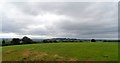
8
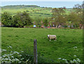
Sheep and field near the summit of Napton on the Hill
Image: © Mat Fascione
Taken: 15 May 2015
0.14 miles
9
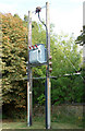
Transformer at Butt Hill
This transformer stands at the triangle junction at the top of Butt Hill. For a wider view of the location see [http://www.geograph.org.uk/photo/1496125] .
Image: © Andy F
Taken: 19 Sep 2009
0.15 miles