1
Victoria Terrace house backs, Stockton
The back of houses on Victoria Terrace [http://www.geograph.org.uk/photo/1313729] seen from Elm Row.
Image: © Andy F
Taken: 21 May 2009
0.01 miles
2
Victoria Terrace, Napton Road, Stockton
Image: © Andy F
Taken: 21 May 2009
0.01 miles
3
Stockton Village Hall
On Napton Road.
Image: © Mike Faherty
Taken: 18 Nov 2018
0.02 miles
4
Houses on Napton Road, Stockton
Image: © Andy F
Taken: 17 May 2009
0.02 miles
5
Timber-framed cottage, Post Office Lane, Stockton
Looking north along Post Office Lane - note the sequoia tree on the left of the cottage. For a wider view of the tree, see [http://www.geograph.org.uk/photo/1308055].
Image: © Andy F
Taken: 17 May 2009
0.03 miles
6
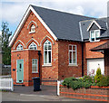
Stockton, former Methodist church
On Post Office Lane; dated 1904, now residential.
Image: © Mike Faherty
Taken: 18 Nov 2018
0.03 miles
7
Stockton, Warwickshire, social club
The Nelson Club on Napton Road, Stockton, Warwickshire looking north-west. The redbrick building beside the club is Stockton Village Hall and beyond is a row of yellow brick terraced cottages which housed workers from the nearby Charles Nelson and Co Ltd cement works which closed in 1949
Image: © Andy F
Taken: Unknown
0.04 miles
8
Chapel House, Stockton
Formerly the Methodist church, Chapel House in Post Office Lane is now a residence.
Image: © Andy F
Taken: 21 May 2009
0.04 miles
9
Grange Farm Drive, Stockton (3)
Grange Farm Drive is a typical modern housing estate on the eastern outskirts of Stockton village, south of Napton Road. The houses are in a variety of vernaculars, some sympathetic to the area, others not. This terrace fits in well - the yellow brickwork with red brick string courses and checket windows reflect the style of older cottages [http://www.geograph.org.uk/photo/155821] in the village.
Image: © Andy F
Taken: 17 May 2009
0.04 miles
10
Stockton, Nelson Club
Club on Napton Road, next to
Image Rectangular open-plan interior, with back counter; drinking areas front, with pool, darts and games machines, and function room upstairs. Cask ales on offer: Hancock's HB, Sharp's Atlantic. Non-members need to be signed in. http://www.nelsonclub.co.uk/
Image: © Mike Faherty
Taken: 18 Nov 2018
0.04 miles


