IMAGES TAKEN NEAR TO
Sycamore Close, SOUTHAM, CV47 8FD
Introduction
This page details the photographs taken nearby to Sycamore Close, CV47 8FD by members of the Geograph project.
The Geograph project started in 2005 with the aim of publishing, organising and preserving representative images for every square kilometre of Great Britain, Ireland and the Isle of Man.

There are currently over 7.5m images from over14,400 individuals and you can help contribute to the project by visiting https://www.geograph.org.uk
Image Map (Loading...)


Getting Data...Please wait
Leaflet Map data © OpenStreetMap
Images are licensed for reuse under creativecommons.org/licenses/by-sa/2.0
Notes
- Clicking on the map will re-center to the selected point.
- The higher the marker number, the further away the image location is from the centre of the postcode.
Image Listing (46 Images Found)
Images are licensed for reuse under creativecommons.org/licenses/by-sa/2.0
Image
Details
Distance
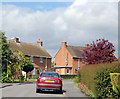
1
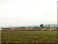
Stockton, Warwickshire
New housing on the southwest fringe of Stockton, Warwickshire. Shuckburgh Hill is on the skyline, right.
Image: © Andy F
Taken: 25 Dec 2008
0.07 miles
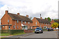
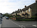
4
High Street, Stockton
High Street opposite the post office in the centre of Stockton village.
Image: © Andy F
Taken: 14 Jan 2009
0.10 miles
5
Mount Pleasant, Stockton
Looking up Mount Pleasant from High Street, Stockton. For another view of this location see http://www.geograph.org.uk/photo/1120312 .
Image: © Andy F
Taken: 14 Jan 2009
0.11 miles

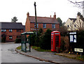
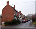
8
Stockton
A row of terraced houses on Napton Road at the junction with George Street.
Image: © David Stowell
Taken: 12 May 2005
0.12 miles
9
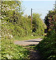
Blue Lias to Stockton Footpath (14)
This footpath runs south-east from the Blue Lias public house beside the Grand Union Canal. At this point, the path emerges in Mount Pleasant [http://www.geograph.org.uk/photo/1120315] in Stockton village.
Image: © Andy F
Taken: 19 Apr 2009
0.12 miles
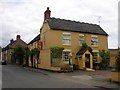
10
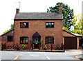
Pear Tree Cottage, village centre, Stockton
Image: © Andy F
Taken: 21 May 2009
0.14 miles