IMAGES TAKEN NEAR TO
Quincy Meadows, SOUTHAM, CV47 8AE
Introduction
This page details the photographs taken nearby to Quincy Meadows, CV47 8AE by members of the Geograph project.
The Geograph project started in 2005 with the aim of publishing, organising and preserving representative images for every square kilometre of Great Britain, Ireland and the Isle of Man.

There are currently over 7.5m images from over14,400 individuals and you can help contribute to the project by visiting https://www.geograph.org.uk
Image Map
Images are licensed for reuse under creativecommons.org/licenses/by-sa/2.0
Notes
- Clicking on the map will re-center to the selected point.
- The higher the marker number, the further away the image location is from the centre of the postcode.
Image Listing (37 Images Found)
Images are licensed for reuse under creativecommons.org/licenses/by-sa/2.0
Image
Details
Distance
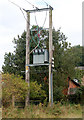
1

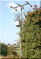
Transformer beside unclassified road in Napton
Image: © Andy F
Taken: 19 Sep 2009
0.05 miles
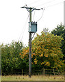
3
Transformer supplying south side of Napton village
Image: © Andy F
Taken: 19 Sep 2009
0.06 miles

7
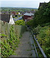
Steps at School Hill in Napton on the Hill
Image: © Mat Fascione
Taken: 15 May 2015
0.14 miles
8
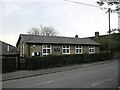
Napton On The Hill
The Old School Building on Vicarage Road.
Image: © Ian Rob
Taken: 3 May 2008
0.14 miles
9
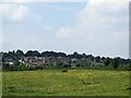
Napton On The Hill
A close up view from Chapel Green.
Image: © Ian Rob
Taken: 19 Jun 2013
0.14 miles