IMAGES TAKEN NEAR TO
Shuckburgh Road, SOUTHAM, CV47 7RY
Introduction
This page details the photographs taken nearby to Shuckburgh Road, CV47 7RY by members of the Geograph project.
The Geograph project started in 2005 with the aim of publishing, organising and preserving representative images for every square kilometre of Great Britain, Ireland and the Isle of Man.

There are currently over 7.5m images from over14,400 individuals and you can help contribute to the project by visiting https://www.geograph.org.uk
Image Map
Images are licensed for reuse under creativecommons.org/licenses/by-sa/2.0
Notes
- Clicking on the map will re-center to the selected point.
- The higher the marker number, the further away the image location is from the centre of the postcode.
Image Listing (6 Images Found)
Images are licensed for reuse under creativecommons.org/licenses/by-sa/2.0
Image
Details
Distance
1
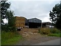
Barns at Northfields Farm
Late August, it is harvest time and the trailer of straw has just pulled in.
Image: © Bikeboy
Taken: 20 Aug 2015
0.02 miles
2
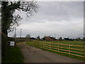
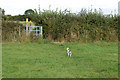
Priors Marston
Marston Farm (according to sign) on map it seems like Northfields Farm in the south of this square.
Image: © Ian Rob
Taken: 5 Nov 2005
0.08 miles
3
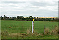
Isolated waymark on a footpath north of Priors Marston
Image: © Andy F
Taken: 13 Oct 2009
0.23 miles
4
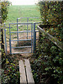
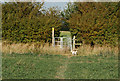
Kissing gate and plank bridge north of Priors Marston
Image: © Andy F
Taken: 13 Oct 2009
0.24 miles
5
Footpath waymark and kissing gate north of Priors Marston
Image: © Andy F
Taken: 13 Oct 2009
0.25 miles
6
Waymarked kissing gate on footpath north of Priors Marston
Image: © Andy F
Taken: 13 Oct 2009
0.25 miles