IMAGES TAKEN NEAR TO
Kestrel Row, SOUTHAM, CV47 2UB
Introduction
This page details the photographs taken nearby to Kestrel Row, CV47 2UB by members of the Geograph project.
The Geograph project started in 2005 with the aim of publishing, organising and preserving representative images for every square kilometre of Great Britain, Ireland and the Isle of Man.

There are currently over 7.5m images from over14,400 individuals and you can help contribute to the project by visiting https://www.geograph.org.uk
Image Map (Loading...)


Getting Data...Please wait
Leaflet Map data © OpenStreetMap
Images are licensed for reuse under creativecommons.org/licenses/by-sa/2.0
Notes
- Clicking on the map will re-center to the selected point.
- The higher the marker number, the further away the image location is from the centre of the postcode.
Image Listing (27 Images Found)
Images are licensed for reuse under creativecommons.org/licenses/by-sa/2.0
Image
Details
Distance
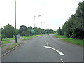
1
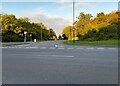
Leamington Road at the junction of Banbury Road
Image: © David Howard
Taken: 17 Oct 2021
0.03 miles
2
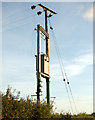
Electricity transformer supplying industrial estate
Image: © Andy F
Taken: 23 Oct 2009
0.06 miles
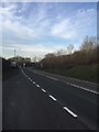
3
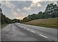
A425 north of Southam Cricket Ground
This is also called the Banbury Road.
Image: © Stuart Logan
Taken: 13 Aug 2012
0.06 miles
5
Layby on the A423
The parking spot for a geocaching walk.
Image: © Dave Thompson
Taken: 13 Dec 2018
0.11 miles
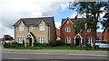
6
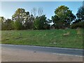
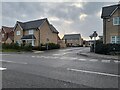
New housing development off Banbury Road, Southam
Image: © JThomas
Taken: 17 Aug 2019
0.13 miles
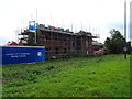
7
Kingfisher Drive, Southam
A new road and development, from Banbury Road.
Image: © David Howard
Taken: 17 Sep 2023
0.13 miles
8
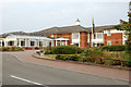
'Galanos House' British Legion residential home, Southam
Image: © Andy F
Taken: 19 Sep 2009
0.13 miles