IMAGES TAKEN NEAR TO
Deppers Bridge, SOUTHAM, CV47 2SY
Introduction
This page details the photographs taken nearby to CV47 2SY by members of the Geograph project.
The Geograph project started in 2005 with the aim of publishing, organising and preserving representative images for every square kilometre of Great Britain, Ireland and the Isle of Man.

There are currently over 7.5m images from over14,400 individuals and you can help contribute to the project by visiting https://www.geograph.org.uk
Image Map (Loading...)


Getting Data...Please wait
Leaflet Map data © OpenStreetMap
Images are licensed for reuse under creativecommons.org/licenses/by-sa/2.0
Notes
- Clicking on the map will re-center to the selected point.
- The higher the marker number, the further away the image location is from the centre of the postcode.
Image Listing (6 Images Found)
Images are licensed for reuse under creativecommons.org/licenses/by-sa/2.0
Image
Details
Distance
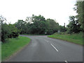
2
Deppers Bridge
Telephone Box,Post Box and traffic calming device on the road to Southam.
Image: © Ian Rob
Taken: 25 Feb 2012
0.07 miles
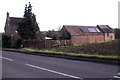
3
Depper's Bridge
A linear hamlet on Depper's Hill
Image: © Dennis Turner
Taken: 17 Dec 2005
0.09 miles
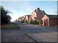
4
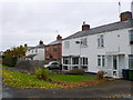
Houses at Deppers Bridge
This row of semi detached houses runs along the north side of the B4451 just west of Deppers Bridge which is where the road crosses the River Itchen.
Image: © Nigel Mykura
Taken: 19 Nov 2012
0.10 miles
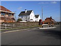
5
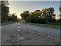
Junction at Deppers Bridge
Harbury Road meets the B4451
Image: © David Howard
Taken: 17 Oct 2021
0.17 miles