IMAGES TAKEN NEAR TO
Featherbed Lane, SOUTHAM, CV47 2DW
Introduction
This page details the photographs taken nearby to Featherbed Lane, CV47 2DW by members of the Geograph project.
The Geograph project started in 2005 with the aim of publishing, organising and preserving representative images for every square kilometre of Great Britain, Ireland and the Isle of Man.

There are currently over 7.5m images from over14,400 individuals and you can help contribute to the project by visiting https://www.geograph.org.uk
Image Map
Images are licensed for reuse under creativecommons.org/licenses/by-sa/2.0
Notes
- Clicking on the map will re-center to the selected point.
- The higher the marker number, the further away the image location is from the centre of the postcode.
Image Listing (13 Images Found)
Images are licensed for reuse under creativecommons.org/licenses/by-sa/2.0
Image
Details
Distance
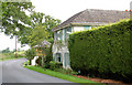
2
Bascote Heath
With the Fox and Hen pub on the right.
Image: © David Stowell
Taken: 24 May 2005
0.17 miles
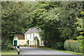
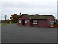
4

Bascote Heath-The Fox and Hen Public House
The Fox and Hen Public House which seems to be made of wood.
Image: © Ian Rob
Taken: 14 May 2010
0.17 miles
5
Fox And Hen public house, Bascote Heath
Compare this view with [http://www.geograph.org.uk/photo/12365]
Image: © Andy F
Taken: 22 Jul 2009
0.18 miles
6
The Fox and Hen
This public house which did not seem to be much more than a grand wooden shed was probably named after the nearby Fox Farm.
Image: © Nigel Mykura
Taken: 19 Nov 2012
0.19 miles
7
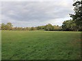
Tunnel Portal for HS2?
If the HS2 plans go ahead then the photographer would be in mid air, looking down a 34 metre deep cutting to the entrance portal of the tunnel running under Long Itchington Wood. The deep cutting would come from the right, and the portal would be about in line with the left hand edge of the picture.
Image: © David P Howard
Taken: 20 Oct 2011
0.23 miles
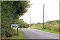
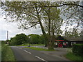
9
Road junction at Bascote Heath
Looking north along the lane to Bascote village where it crosses Welsh Road.
Image: © Andy F
Taken: 22 Jul 2009
0.24 miles
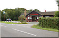
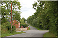
10
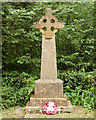
Bascote Heath war memorial
Marked on the 1:50000 OS map, the memorial stands on the east side of the road through Bascote Heath. The inscription reads: 'In honoured memory of the men from Bascote Heath and Stoney Thorpe who died in the Great War 1914 - 1948'
Image: © Andy F
Taken: 22 Jul 2009
0.24 miles