IMAGES TAKEN NEAR TO
Ladbroke, SOUTHAM, CV47 2DB
Introduction
This page details the photographs taken nearby to CV47 2DB by members of the Geograph project.
The Geograph project started in 2005 with the aim of publishing, organising and preserving representative images for every square kilometre of Great Britain, Ireland and the Isle of Man.

There are currently over 7.5m images from over14,400 individuals and you can help contribute to the project by visiting https://www.geograph.org.uk
Image Map
Images are licensed for reuse under creativecommons.org/licenses/by-sa/2.0
Notes
- Clicking on the map will re-center to the selected point.
- The higher the marker number, the further away the image location is from the centre of the postcode.
Image Listing (7 Images Found)
Images are licensed for reuse under creativecommons.org/licenses/by-sa/2.0
Image
Details
Distance
2
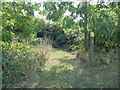
Ascote Bridleway
Totally overgrown entrance to the bridleway opposite Ascote Cottage.
Image: © Ian Rob
Taken: 1 Oct 2011
0.05 miles
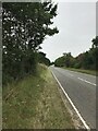
4
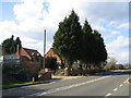
Ascote
The cottages beside the busy Banbury Road, looking NW.
Image: © David Stowell
Taken: 4 Apr 2006
0.07 miles
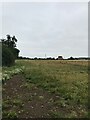
5
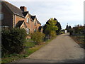
Hodnell Cottage
At the entrance to Hodnell Manor.
Image: © Ian Rob
Taken: 1 Oct 2011
0.15 miles
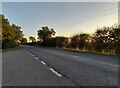
6
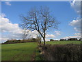
Footpath past Hodnell Manor
Looking SE along the footpath as it follows the hedge, with Hodnell Manor concealed in the trees on top of the hill to the right.
Image: © David Stowell
Taken: 4 Apr 2006
0.19 miles