IMAGES TAKEN NEAR TO
Avon Dassett, SOUTHAM, CV47 2AQ
Introduction
This page details the photographs taken nearby to CV47 2AQ by members of the Geograph project.
The Geograph project started in 2005 with the aim of publishing, organising and preserving representative images for every square kilometre of Great Britain, Ireland and the Isle of Man.

There are currently over 7.5m images from over14,400 individuals and you can help contribute to the project by visiting https://www.geograph.org.uk
Image Map (Loading...)


Getting Data...Please wait
Leaflet Map data © OpenStreetMap
Images are licensed for reuse under creativecommons.org/licenses/by-sa/2.0
Notes
- Clicking on the map will re-center to the selected point.
- The higher the marker number, the further away the image location is from the centre of the postcode.
Image Listing (5 Images Found)
Images are licensed for reuse under creativecommons.org/licenses/by-sa/2.0
Image
Details
Distance
1
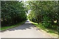
Avon Dassett-Oxbow Farm
The long tree lined road.
Image: © Ian Rob
Taken: 16 Jul 2019
0.16 miles
2

Towards Farnborough
The obelisk at Farnborough Hall is visible in the distance.
Image: © Andrew Tatlow
Taken: 13 Aug 2012
0.17 miles
3
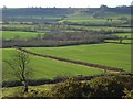
Farmland, Avon Dassett
Flat arable fields and the M40 occupy the valley between here and Edge Hill. Viewed from the hillside between Avon Dassett and Farnborough.
Image: © Andrew Smith
Taken: 12 Jan 2008
0.22 miles
4
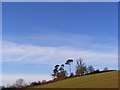
Copse on hillside, Avon Dassett
The ground in the foreground is arable farmland. Beyond the copse it steepens slightly and becomes pastoral.
Image: © Andrew Smith
Taken: 12 Jan 2008
0.24 miles
5
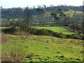
Farmland and copse, Avon Dassett
In the foreground is the edge of a steep area of pasture with gorse bushes. Beyond is arable land above a copse with prominent pines. The obelisk in Farnborough Park can be seen in the distance.
Image: © Andrew Smith
Taken: 12 Jan 2008
0.24 miles