IMAGES TAKEN NEAR TO
Welsh Road East, SOUTHAM, CV47 1NB
Introduction
This page details the photographs taken nearby to Welsh Road East, CV47 1NB by members of the Geograph project.
The Geograph project started in 2005 with the aim of publishing, organising and preserving representative images for every square kilometre of Great Britain, Ireland and the Isle of Man.

There are currently over 7.5m images from over14,400 individuals and you can help contribute to the project by visiting https://www.geograph.org.uk
Image Map
Images are licensed for reuse under creativecommons.org/licenses/by-sa/2.0
Notes
- Clicking on the map will re-center to the selected point.
- The higher the marker number, the further away the image location is from the centre of the postcode.
Image Listing (7 Images Found)
Images are licensed for reuse under creativecommons.org/licenses/by-sa/2.0
Image
Details
Distance
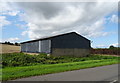
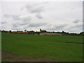
2
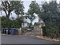
Isolated house on Welsh Road East
Oddly it is west of the remainder of Welsh Road. The barn on the left was added since the last view of 2009.
Image: © David Howard
Taken: 17 Sep 2023
0.16 miles
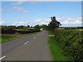
4
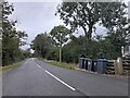
Welsh Road East before Southam
Oddly this is west of the rest of Welsh Road
Image: © David Howard
Taken: 17 Sep 2023
0.18 miles
5
Ladbroke Hill
Seen across the square from Welsh Road East
Image: © David Stowell
Taken: 29 May 2005
0.18 miles
6
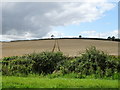
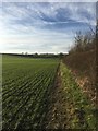
Hillside cereal crop, Southam Holt
Off Welsh Road East.
Image: © JThomas
Taken: 17 Aug 2019
0.21 miles