IMAGES TAKEN NEAR TO
Lime Road, SOUTHAM, CV47 1EQ
Introduction
This page details the photographs taken nearby to Lime Road, CV47 1EQ by members of the Geograph project.
The Geograph project started in 2005 with the aim of publishing, organising and preserving representative images for every square kilometre of Great Britain, Ireland and the Isle of Man.

There are currently over 7.5m images from over14,400 individuals and you can help contribute to the project by visiting https://www.geograph.org.uk
Image Map (Loading...)


Getting Data...Please wait
Leaflet Map data © OpenStreetMap
Images are licensed for reuse under creativecommons.org/licenses/by-sa/2.0
Notes
- Clicking on the map will re-center to the selected point.
- The higher the marker number, the further away the image location is from the centre of the postcode.
Image Listing (29 Images Found)
Images are licensed for reuse under creativecommons.org/licenses/by-sa/2.0
Image
Details
Distance
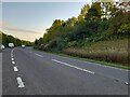
1
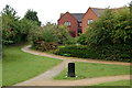
Footpaths at south end of Merestone Close beside Southam bypass
Image: © Andy F
Taken: 5 Aug 2009
0.01 miles
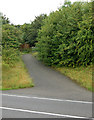
2
Footpath to Stockton from Southam
Looking east from Coventry Road at the start of a public footpath to Stockton.
Image: © Andy F
Taken: 17 May 2009
0.07 miles
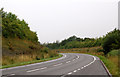
3
Footpath from Stockton crossing Southam bypass
Image: © Andy F
Taken: 5 Aug 2009
0.08 miles

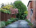
9
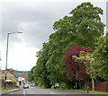
Coventry Road, Southam
Looking south towards Southam town centre. The camera is level, it's the lamp-post that is out of kilter.
Image: © Andy F
Taken: 17 May 2009
0.14 miles
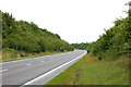
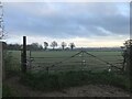
10

Footpath to Stockton looking east from Southam bypass
Image: © Andy F
Taken: 5 Aug 2009
0.15 miles