IMAGES TAKEN NEAR TO
Swordfish Avenue, SOUTHAM, CV47 1AZ
Introduction
This page details the photographs taken nearby to Swordfish Avenue, CV47 1AZ by members of the Geograph project.
The Geograph project started in 2005 with the aim of publishing, organising and preserving representative images for every square kilometre of Great Britain, Ireland and the Isle of Man.

There are currently over 7.5m images from over14,400 individuals and you can help contribute to the project by visiting https://www.geograph.org.uk
Image Map
Images are licensed for reuse under creativecommons.org/licenses/by-sa/2.0
Notes
- Clicking on the map will re-center to the selected point.
- The higher the marker number, the further away the image location is from the centre of the postcode.
Image Listing (4 Images Found)
Images are licensed for reuse under creativecommons.org/licenses/by-sa/2.0
Image
Details
Distance
1
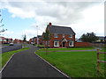
New housing development off Welsh Road East
Image: © JThomas
Taken: 17 Aug 2019
0.17 miles
3
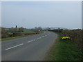
Daventry Road (A425)
Heading east out of Southam.
Image: © JThomas
Taken: 28 Mar 2014
0.24 miles
4
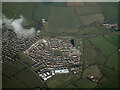
Flying Fields housing development from the air
A Taylor-Wimpey development at Southam. Viewed from a Birmingham bound flight from Prague.
Image: © Thomas Nugent
Taken: 11 Feb 2022
0.24 miles