IMAGES TAKEN NEAR TO
Holt Road, SOUTHAM, CV47 1AJ
Introduction
This page details the photographs taken nearby to Holt Road, CV47 1AJ by members of the Geograph project.
The Geograph project started in 2005 with the aim of publishing, organising and preserving representative images for every square kilometre of Great Britain, Ireland and the Isle of Man.

There are currently over 7.5m images from over14,400 individuals and you can help contribute to the project by visiting https://www.geograph.org.uk
Image Map (Loading...)


Getting Data...Please wait
Leaflet Map data © OpenStreetMap
Images are licensed for reuse under creativecommons.org/licenses/by-sa/2.0
Notes
- Clicking on the map will re-center to the selected point.
- The higher the marker number, the further away the image location is from the centre of the postcode.
Image Listing (7 Images Found)
Images are licensed for reuse under creativecommons.org/licenses/by-sa/2.0
Image
Details
Distance

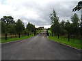
3
Napton Holt
Holt Farm Caravan and Camping Site.
Image: © Ian Rob
Taken: 14 May 2010
0.18 miles
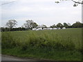
6
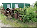
Napton Holt Farm Tractor
At the entrance to the campsite.
Image: © Ian Rob
Taken: 19 Jun 2013
0.21 miles
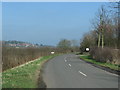
7
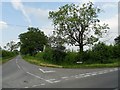
Holt Road
The road to Napton from Welsh Road.
Image: © Ian Rob
Taken: 19 Jun 2013
0.24 miles