IMAGES TAKEN NEAR TO
Hillyard Road, SOUTHAM, CV47 0LD
Introduction
This page details the photographs taken nearby to Hillyard Road, CV47 0LD by members of the Geograph project.
The Geograph project started in 2005 with the aim of publishing, organising and preserving representative images for every square kilometre of Great Britain, Ireland and the Isle of Man.

There are currently over 7.5m images from over14,400 individuals and you can help contribute to the project by visiting https://www.geograph.org.uk
Image Map (Loading...)


Getting Data...Please wait
Leaflet Map data © OpenStreetMap
Images are licensed for reuse under creativecommons.org/licenses/by-sa/2.0
Notes
- Clicking on the map will re-center to the selected point.
- The higher the marker number, the further away the image location is from the centre of the postcode.
Image Listing (22 Images Found)
Images are licensed for reuse under creativecommons.org/licenses/by-sa/2.0
Image
Details
Distance
1
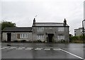
Southam-Welsh Road West
Cottage at the junction with Mill Road.
Image: © Ian Rob
Taken: 25 Aug 2014
0.14 miles
3
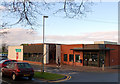
Southam Leisure Centre
Southam Leisure Centre is on Welsh Road West, Southam, Warwickshire.
Image: © Andy F
Taken: 2 Jan 2009
0.17 miles
4
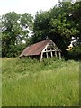
Abandoned building on path to Holy Well
Image: © Dave Thompson
Taken: 26 Jun 2015
0.17 miles
5
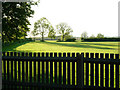
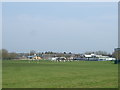
Southam College playing field
Seen here from the adjacent leisure centre car park, this extensive playing field belongs to Southam College (actually a comprehensive school) off Welsh Road West on the edge of the town.
Image: © Stephen McKay
Taken: 19 May 2009
0.18 miles
8
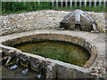
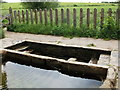
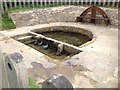
The Holy Well, Southam
According to the information board adjacent:
"The Holy Well is a scheduled Ancient Monument and a Grade 2 listed building. It is reputed to have been used by monks in this area - hence the Holy Well. An early reference to the HALEWELLENE occurs in the Warwickshire Feet of Fines 1206 (ancient records of property transactions). The current stonework was probably built late 18th /early 19th century with further repairs in about 1926. Following the improvement in the water supply to the well in 2004, sympathetic restoration was carried out in 2005-6"
Image: © John Brightley
Taken: 23 Jun 2012
0.19 miles