IMAGES TAKEN NEAR TO
Aston Cantlow Road, STRATFORD-UPON-AVON, CV37 9XZ
Introduction
This page details the photographs taken nearby to Aston Cantlow Road, CV37 9XZ by members of the Geograph project.
The Geograph project started in 2005 with the aim of publishing, organising and preserving representative images for every square kilometre of Great Britain, Ireland and the Isle of Man.

There are currently over 7.5m images from over14,400 individuals and you can help contribute to the project by visiting https://www.geograph.org.uk
Image Map
Images are licensed for reuse under creativecommons.org/licenses/by-sa/2.0
Notes
- Clicking on the map will re-center to the selected point.
- The higher the marker number, the further away the image location is from the centre of the postcode.
Image Listing (7 Images Found)
Images are licensed for reuse under creativecommons.org/licenses/by-sa/2.0
Image
Details
Distance
1
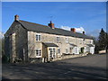
Cottages in Wilmcote
By the Aston Cantlow Road.
Image: © David Stowell
Taken: 18 Feb 2006
0.04 miles
2
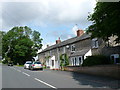
Houses on the Aston Cantlow Road
This row of old stone terraced cottages was probably built originally for farmworkers.
Image: © Nigel Mykura
Taken: 21 Jul 2012
0.05 miles
3
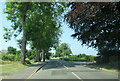
Aston Cantlow Road Wilmcote passing Gypsy Hall Farm sign
Image: © Roy Hughes
Taken: 21 Jul 2021
0.09 miles
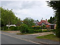
4
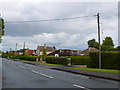
Aston Cantlow Rd Wilmcote
These bungalows and detached houses are on the north side of the minor road running out of the village to the west towards Aston Holdings and Aston Cantlow.
Image: © Nigel Mykura
Taken: 10 Jun 2011
0.11 miles
5
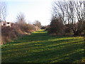
Wide grass track behind houses
Footpath is alongside planted access area.
Image: © Liz Stone
Taken: 2 Jan 2012
0.19 miles
6
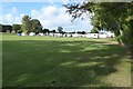
Holiday park at Wilmcote
Campervans in a holiday park at Wilmcote.
Image: © Philip Halling
Taken: 1 Oct 2022
0.21 miles
7
Houses at Wilmcote
These bungalows run along the south side of the road out of the village to the west towards Aston Holdings.
Image: © Nigel Mykura
Taken: 10 Jun 2011
0.23 miles