IMAGES TAKEN NEAR TO
Bordon Hill, STRATFORD-UPON-AVON, CV37 9RX
Introduction
This page details the photographs taken nearby to Bordon Hill, CV37 9RX by members of the Geograph project.
The Geograph project started in 2005 with the aim of publishing, organising and preserving representative images for every square kilometre of Great Britain, Ireland and the Isle of Man.

There are currently over 7.5m images from over14,400 individuals and you can help contribute to the project by visiting https://www.geograph.org.uk
Image Map
Images are licensed for reuse under creativecommons.org/licenses/by-sa/2.0
Notes
- Clicking on the map will re-center to the selected point.
- The higher the marker number, the further away the image location is from the centre of the postcode.
Image Listing (7 Images Found)
Images are licensed for reuse under creativecommons.org/licenses/by-sa/2.0
Image
Details
Distance
1
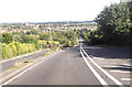
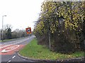
B439 down the hill passing Bordon Hill Nurseries
Image: © John Firth
Taken: 22 Sep 2012
0.03 miles
3
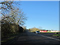
Bordon Hill
The B439 Evesham Road as it leaves Stratford-upon-Avon heading west, climbs Bordon Hill.
Image: © David P Howard
Taken: 7 Feb 2012
0.18 miles
5
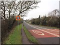
Crab-apples by the Evesham Road
A tree by the side of the B439 Evesham Road at the bottom of Bordon Hill, still laden with crab-apples in February.
Image: © David P Howard
Taken: 7 Feb 2012
0.21 miles
6
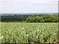
View ENE from footpath to Shottery from Drayton
Looking out over a field of broad beans, towards Stratford-upon-Avon in the distance. Just left of centre is the new tower at the Royal Shakespeare Company Image On the right hand side is the spire of Holy Trinity Church Image
Image: © David P Howard
Taken: 12 Jun 2010
0.22 miles
7
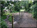
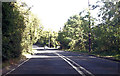
New fence on footpath to Drayton from Shottery
It looks as though the footpath had veered to the left over time due to the poor state of repair of the original fencing and the growth of the hedge on the right. The hedge has been cut back, and a new fence erected to reinstate the original route of the path.
Image: © David P Howard
Taken: 12 Jun 2010
0.23 miles