IMAGES TAKEN NEAR TO
Holly Walk, STRATFORD-UPON-AVON, CV37 9LR
Introduction
This page details the photographs taken nearby to Holly Walk, CV37 9LR by members of the Geograph project.
The Geograph project started in 2005 with the aim of publishing, organising and preserving representative images for every square kilometre of Great Britain, Ireland and the Isle of Man.

There are currently over 7.5m images from over14,400 individuals and you can help contribute to the project by visiting https://www.geograph.org.uk
Image Map
Images are licensed for reuse under creativecommons.org/licenses/by-sa/2.0
Notes
- Clicking on the map will re-center to the selected point.
- The higher the marker number, the further away the image location is from the centre of the postcode.
Image Listing (32 Images Found)
Images are licensed for reuse under creativecommons.org/licenses/by-sa/2.0
Image
Details
Distance
1
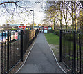
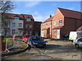
Bishopton Community Centre Car Park
The car park for the use of the community centre, accessed from the far end off Drayton Avenue.
Many local clubs and societies use the community centre, including Stratford Photo Group. http://www.stratfordphotographic.org.uk/
Image: © David P Howard
Taken: 21 Apr 2015
0.06 miles
2
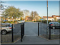
Bishopton Community Centre
The entrance to Bishopton Community Centre off Drayton Avenue.
The centre is the building on the right through the wooden gate ahead.
The car park for the use of the centre is on the left. Access is at the other end off Drayton Avenue.
The community centre is used by many local groups and societies, including Stratford Photo Group. http://www.stratfordphotographic.org.uk/
Image: © David P Howard
Taken: 21 Apr 2015
0.07 miles
3
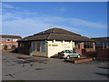
The Squirrel, Bishopton
A modern estate pub in this still growing residential area in the west of Stratford-upon-Avon.
Image: © David Stowell
Taken: 15 Feb 2006
0.08 miles
4
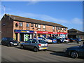
Bishopton Shops
The local shopping centre in this modern housing estate.
Image: © David Stowell
Taken: 15 Feb 2006
0.08 miles
5
Scholars Gate, Bishopton
This recent development is, as the name popular with developers suggests, built on the site of one of the two schools shown on the current OS maps at this grid reference.
Image: © David Stowell
Taken: 15 Feb 2006
0.13 miles
6

Broadmeadow Lane
Houses on Broadmeadow Lane off Bishopton Lane in Stratford-upon-Avon.
Image: © Philip Halling
Taken: 3 Aug 2019
0.15 miles
7
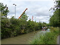
The Stratford-upon-Avon Canal from the towpath, with cranes
Image: © Ruth Sharville
Taken: 22 Aug 2022
0.19 miles
8
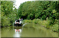
Stratford-upon-Avon Canal in Stratford, Warwickshire
Image: © Roger D Kidd
Taken: 26 Aug 2012
0.20 miles
9

Lock 51, Bishopton
On the Stratford upon Avon canal as it encounters the outskirts of the town with a modern housing estate just visible behind the bushes in the left and a new industrial estate just out of view of the camera to the right.
Image: © David Stowell
Taken: 1 Oct 2005
0.20 miles
10
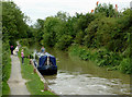
Stratford-upon-Avon Canal near Bishopton, Warwickshire
The narrowboat crew is waiting to enter Bishopton Lock, No 51.
Image: © Roger D Kidd
Taken: 24 Aug 2012
0.20 miles