IMAGES TAKEN NEAR TO
Masons Road, STRATFORD-UPON-AVON, CV37 9LQ
Introduction
This page details the photographs taken nearby to Masons Road, CV37 9LQ by members of the Geograph project.
The Geograph project started in 2005 with the aim of publishing, organising and preserving representative images for every square kilometre of Great Britain, Ireland and the Isle of Man.

There are currently over 7.5m images from over14,400 individuals and you can help contribute to the project by visiting https://www.geograph.org.uk
Image Map
Images are licensed for reuse under creativecommons.org/licenses/by-sa/2.0
Notes
- Clicking on the map will re-center to the selected point.
- The higher the marker number, the further away the image location is from the centre of the postcode.
Image Listing (47 Images Found)
Images are licensed for reuse under creativecommons.org/licenses/by-sa/2.0
Image
Details
Distance
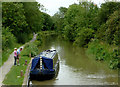
1
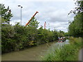
The Stratford-upon-Avon Canal from the towpath, with cranes
Image: © Ruth Sharville
Taken: 22 Aug 2022
0.09 miles
2
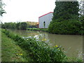
Industrial building beside the Stratford-Upon-Avon Canal
Image: © Rod Allday
Taken: 12 Jun 2019
0.09 miles
3
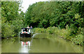
Stratford-upon-Avon Canal in Stratford, Warwickshire
Image: © Roger D Kidd
Taken: 26 Aug 2012
0.12 miles
4
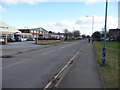
Timothy Bridge Road industrial units, Stratford upon Avon
The town relies on real industries of the 20th and 21st centuries too.
Image: © Jeremy Bolwell
Taken: 11 Feb 2010
0.12 miles
5
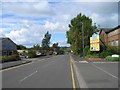
Timothy's Bridge Road, Stratford-Upon-Avon
This is the light industrial area of Stratford with small to medium units, offices, etc. Some are For Sale/To Let like the one in the photo.
Image: © David P Howard
Taken: 16 Sep 2010
0.13 miles
6
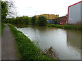
Towpath along the Stratford-upon-Avon Canal
Image: © Mat Fascione
Taken: 4 May 2015
0.15 miles
7
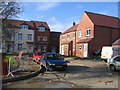
Scholars Gate, Bishopton
This recent development is, as the name popular with developers suggests, built on the site of one of the two schools shown on the current OS maps at this grid reference.
Image: © David Stowell
Taken: 15 Feb 2006
0.17 miles
8

Stratford upon Avon
Looking WNW from near the top of Long Hill, above Loxley, across the fields of the Avon Valley, towards the town of Stratford upon Avon in the distance.
The large office block in the centre of the image is the Morgan Sindall Group building at 20 Timothy's Bridge Road, some 7.3 km away.
The Royal Shakespeare Theatre can be seen towards the left hand edge, with the new observation tower standing out quite well.
Image: © David P Howard
Taken: 29 Jul 2016
0.17 miles
9
Shottery Brook - upstream of the Stratford Canal
The Shottery Brook is a tributary of the River Avon.
Image: © John M
Taken: 6 Mar 2011
0.17 miles
10
Canal approaching Stratford-upon-Avon, Warwickshire
This is below Bishopton Lock, No 51. The boat crew has moored loosely until a boat bound for Stratford leaves the lock.
Image: © Roger D Kidd
Taken: 24 Aug 2012
0.17 miles