IMAGES TAKEN NEAR TO
Moss Lane, STRATFORD-UPON-AVON, CV37 8TU
Introduction
This page details the photographs taken nearby to Moss Lane, CV37 8TU by members of the Geograph project.
The Geograph project started in 2005 with the aim of publishing, organising and preserving representative images for every square kilometre of Great Britain, Ireland and the Isle of Man.

There are currently over 7.5m images from over14,400 individuals and you can help contribute to the project by visiting https://www.geograph.org.uk
Image Map
Images are licensed for reuse under creativecommons.org/licenses/by-sa/2.0
Notes
- Clicking on the map will re-center to the selected point.
- The higher the marker number, the further away the image location is from the centre of the postcode.
Image Listing (41 Images Found)
Images are licensed for reuse under creativecommons.org/licenses/by-sa/2.0
Image
Details
Distance
1

Newbold-on-Stour village hall
Seen from Newbold Green.
Image: © Michael Dibb
Taken: 22 Sep 2010
0.03 miles
2

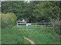
End of road, start of bridleway
The bridleway which runs to Ilmington starts here in Newbold-on-Stour where the road ends.
Image: © Michael Dibb
Taken: 22 Sep 2010
0.04 miles
3
Into Newbold-on-Stour
The bridleway ends as it reaches Newbold-on-Stour.
Image: © Michael Dibb
Taken: 22 Sep 2010
0.04 miles
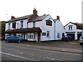
6
Bird in the Hand, Newbold-on-Stour
Image: © Alexander P Kapp
Taken: 15 May 2009
0.05 miles
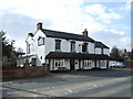
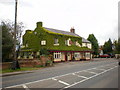
8
The Bird in Hand
One of the two public houses in Newbold-on-Stour.
Image: © Michael Dibb
Taken: 10 Dec 2011
0.06 miles
10
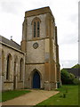
The Parish Church of St David, Newbold-on-Stour, Tower
Image: © Alexander P Kapp
Taken: 15 May 2009
0.06 miles